La sierra équatorienne : régionalisation et analyse des données. Scale of 1:1 000 000 to 1:750 000. Date of publication: 1984-1986.
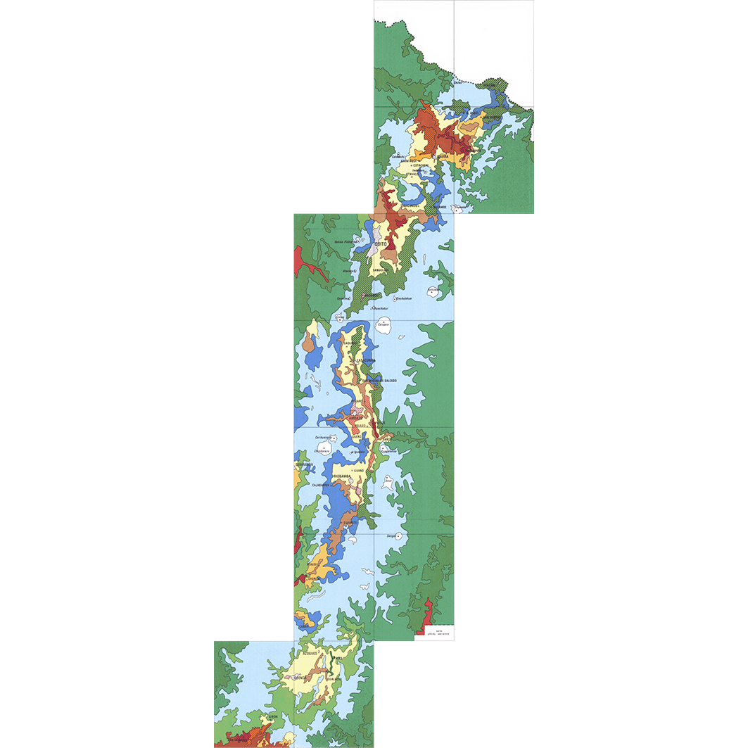
1. Andes équatoriennes : croquis d'utilisation actuelle des sols. / Gondard, P.; Valton, C. (ill.); Scale of 1:1 000 000. Date of publication: 1986. (file: 01365RC_IRD_ECU_USOL_1986_1000000_IRD_ECU_CSRE_1984-86_1000000-750000.tif) 2. Equateur - Sierra : conditions physiques - potentialités (bloc 1). / Thomassin, Marie-Madeleine; Scale of 1:750 000. Date of publication: 1984. (file: 01363RC_IRD_ECU_EVPH_1984_750000_IRD_ECU_CSRE_1984-86_1000000-750000.tif) 3. Equateur - Sierra : critères socio-économiques (bloc 3a). / Thomassin, Marie Madeleine; Scale of 1:750 000. Date of publication: 1984. (file: 01366RC_IRD_ECU_POSE_1984_750000_IRD_ECU_CSRE_1984-86_1000000-750000.tif) 4. Equateur - Sierra : totalité des données B1, B2, et B3a ; soit 48 variables (205 modalités) croisées avec 238 paroisses. / Thomassin, Marie Madeleine; Scale of 1:750 000. Date of publication: 1984. (file: 01367RC_IRD_ECU_POSE_1984_750000_IRD_ECU_CSRE_1984-86_1000000-750000.tif)
Overview
Lineage
2. Georeferencing and if possible reprojection to WGS84 (Longitude / Latitude).
3. Clipping and mosaicing of map sheets(s).
4. Export ECW format.
5. ECW to GeoTIFF format conversion.
Links
Downloads
- sphaera_ws:01365RC_IRD_ECU_USOL_1986_1000000_IRD_ECU_CSRE_1984-86_1000000-750000 Andes équatoriennes : croquis d'utilisation actuelle des sols.
- link
- sphaera_ws:01363RC_IRD_ECU_EVPH_1984_750000_IRD_ECU_CSRE_1984-86_1000000-750000 Equateur - Sierra : conditions physiques - potentialités (bloc 1).
- Télécharger au format GeoTIFF Télécharger au format GeoTIFF
- sphaera_ws:01366RC_IRD_ECU_POSE_1984_750000_IRD_ECU_CSRE_1984-86_1000000-750000 Equateur - Sierra : critères socio-économiques (bloc 3a).
- Télécharger au format GeoTIFF Télécharger au format GeoTIFF
- sphaera_ws:01367RC_IRD_ECU_POSE_1984_750000_IRD_ECU_CSRE_1984-86_1000000-750000 Equateur - Sierra : totalité des données B1, B2, et B3a ; soit 48 variables (205 modalités) croisées avec 238 paroisses.
- Télécharger au format GeoTIFF Télécharger au format GeoTIFF
Geolinks
- sphaera_ws:01365RC_IRD_ECU_USOL_1986_1000000_IRD_ECU_CSRE_1984-86_1000000-750000 Andes équatoriennes : croquis d'utilisation actuelle des sols.
- sphaera_ws:01363RC_IRD_ECU_EVPH_1984_750000_IRD_ECU_CSRE_1984-86_1000000-750000 Equateur - Sierra : conditions physiques - potentialités (bloc 1).
- sphaera_ws:01366RC_IRD_ECU_POSE_1984_750000_IRD_ECU_CSRE_1984-86_1000000-750000 Equateur - Sierra : critères socio-économiques (bloc 3a).
- sphaera_ws:01367RC_IRD_ECU_POSE_1984_750000_IRD_ECU_CSRE_1984-86_1000000-750000 Equateur - Sierra : totalité des données B1, B2, et B3a ; soit 48 variables (205 modalités) croisées avec 238 paroisses.
Others
- Notice explicative ou autre ouvrage Document associé à la carte
- Link to Original Record [datasuds-geo.ird.fr] This metadata comes from datasuds-geo.ird.fr
- Notice explicative ou autre ouvrage Document associé à la carte
- Notice explicative ou autre ouvrage Document associé à la carte
- Notice explicative ou autre ouvrage Document associé à la carte
- Digital Object Identifier (DOI)