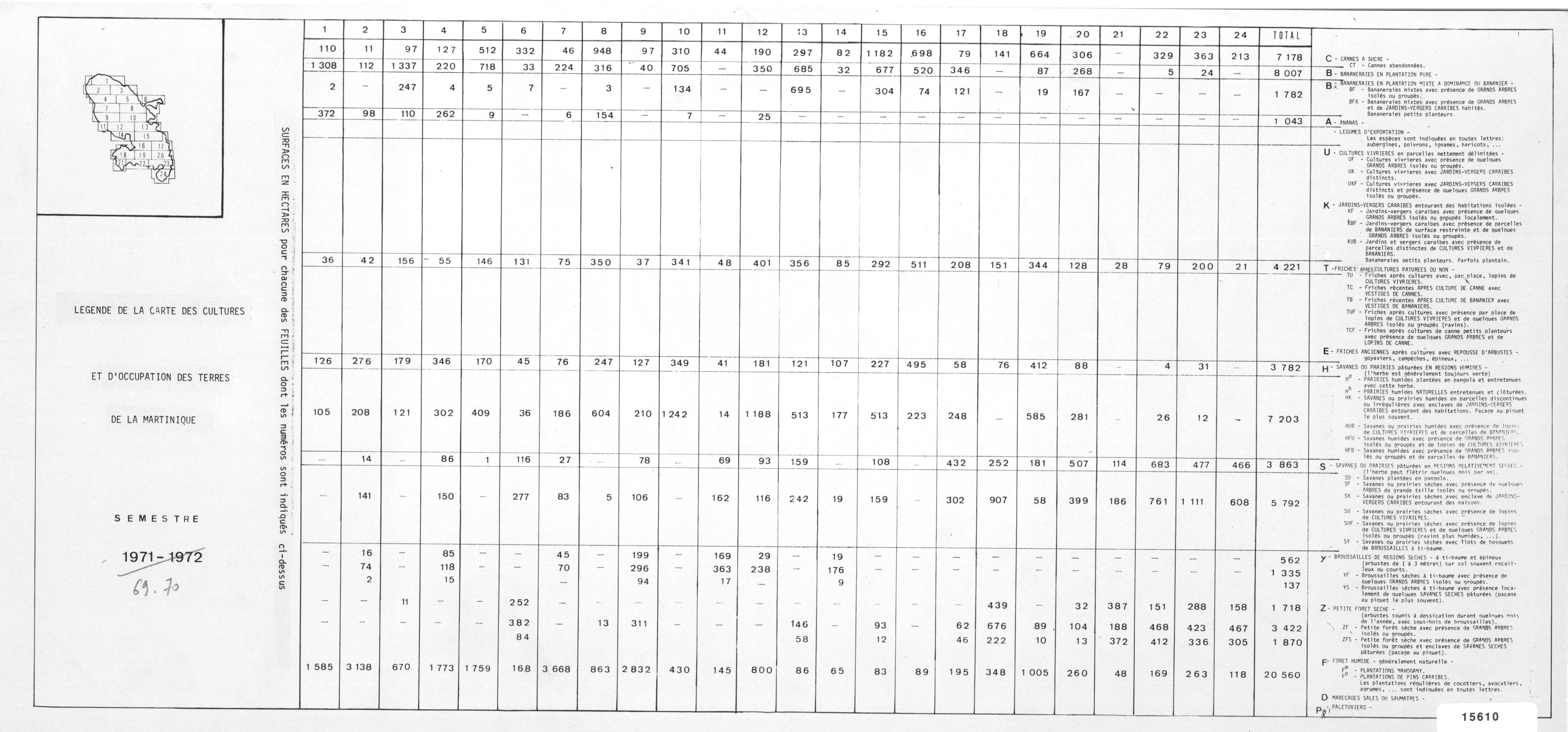
Carte des cultures et d'occupation des terres de la Martinique : 1969. Scale of 1:50 000. Date of publication: 1969.
IDS IRD
1. Carte des cultures et d'occupation des terres de la Martinique : 1969. / Colmet Daage, F. (dir.); Pallud, Alfred (ill.); Rofallet, J. C. (ill.); Bernard, J. (collab.) Scale of 1:50 000. Date of publication: 1969. (file: 02939RC_IRD_MTQ_USOL_1969_50000_IRD_MTQ_USOL_1969_50000.tif)
publicationDec 31, 1968
Temporal CoverageJan 1, 1969Dec 31, 1969
Overview
1 / 3
Lineage
1. Scanning to tif format, 256 colors, 250dpi.
2. Georeferencing and if possible reprojection to WGS84 (Longitude / Latitude).
3. Clipping and mosaicing of map sheets(s).
4. Export ECW format.
5. ECW to GeoTIFF format conversion.
2. Georeferencing and if possible reprojection to WGS84 (Longitude / Latitude).
3. Clipping and mosaicing of map sheets(s).
4. Export ECW format.
5. ECW to GeoTIFF format conversion.
Links
Downloads
- sphaera_ws:02939RC_IRD_MTQ_USOL_1969_50000_IRD_MTQ_USOL_1969_50000 Carte des cultures et d'occupation des terres de la Martinique : 1969.
- link
Geolinks
- sphaera_ws:02939RC_IRD_MTQ_USOL_1969_50000_IRD_MTQ_USOL_1969_50000 Carte des cultures et d'occupation des terres de la Martinique : 1969.
Others
- Link to Original Record [datasuds-geo.ird.fr] This metadata comes from datasuds-geo.ird.fr
- Digital Object Identifier (DOI)
Keywords
Constraints
licence
Use limitations
Licence : CC-BY-NC-SA