Atlas Régional Bénoué. Scale of 1:2 000 000 to 1:500 000. Date of publication: 1971-1975.
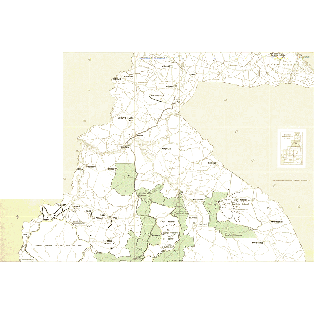
1. Carte cynégétique et touristique. / Boulet, J.; Séguin, L. (ill.); Scale of 1:1 000 000. Date of publication: 1975. (file: 02231RC_IRD_CMR_INTO_1975_1000000_IRD_CMR_AAAA_1971-75_2000000-500000.tif) 2. Carte hydrogéologique du Cameroun : Garoua. / Tillement, B.; Dauteloup, J. (ill.); Scale of 1:2 000 000 to 1:500 000. Date of publication: 1971. (files: 02232RC_IRD_CMR_GEHY_1971_2000000_IRD_CMR_AAAA_1971-75_2000000-500000.tif, 02232RC_IRD_CMR_GEHY_1971_500000_IRD_CMR_AAAA_1971-75_2000000-500000.tif) 3. Circonscriptions administratives. / Boulet, J.; Séguin, L. (ill.); Scale of 1:500 000. Date of publication: 1974. (file: 02228RC_IRD_CMR_ADMI_1974_500000_IRD_CMR_AAAA_1971-75_2000000-500000.tif) 4. Densité de la population. / Boulet, J.; Séguin, L. (ill.); Scale of 1:500 000. Date of publication: 1975. (file: 02230RC_IRD_CMR_PODE_1975_500000_IRD_CMR_AAAA_1971-75_2000000-500000.tif) 5. Élevage. / Boulet, J.; Séguin, L. (ill.); Scale of 1:1 000 000. Date of publication: 1975. (file: 02235RC_IRD_CMR_AGEL_1975_1000000_IRD_CMR_AAAA_1971-75_2000000-500000.tif) 6. Infrastructure. / Barral, Henri; Boulet, J.; Courade, Georges; Franqueville, A.; Séguin, L. (ill.); Scale of 1:500 000. Date of publication: 1974. (file: 02226RC_IRD_CMR_INFR_1974_500000_IRD_CMR_AAAA_1971-75_2000000-500000.tif) 7. Plantes cultivées : A. / Boulet, J.; Séguin, L. (ill.); Scale of 1:500 000. Date of publication: 1975. (file: 02234RC_IRD_CMR_AGCU_1975_500000_IRD_CMR_AAAA_1971-75_2000000-500000.tif) 8. Plantes cultivées : B. / Boulet, J.; Séguin, L. (ill.); Scale of 1:500 000. Date of publication: 1975. (file: 02233RC_IRD_CMR_AGCU_1975_500000_IRD_CMR_AAAA_1971-75_2000000-500000.tif) 9. Populations. / Barral, Henri; Boulet, J.; Franqueville, A.; Séguin, L. (ill.); Scale of 1:500 000. Date of publication: 1974. (file: 02227RC_IRD_CMR_POPU_1974_500000_IRD_CMR_AAAA_1971-75_2000000-500000.tif) 10. Utilisation actuelle de l'espace. / Boulet, J.; Séguin, L. (ill.); Scale of 1:500 000. Date of publication: 1975. (file: 02229RC_IRD_CMR_USOL_1975_500000_IRD_CMR_AAAA_1971-75_2000000-500000.tif)
Overview
Lineage
2. Georeferencing and if possible reprojection to WGS84 (Longitude / Latitude).
3. Clipping and mosaicing of map sheets(s).
4. Export ECW format.
5. ECW to GeoTIFF format conversion.
Links
Downloads
- sphaera_ws:02231RC_IRD_CMR_INTO_1975_1000000_IRD_CMR_AAAA_1971-75_2000000-500000 Carte cynégétique et touristique.
- link
- sphaera_ws:02232RC_IRD_CMR_GEHY_1971_2000000_IRD_CMR_AAAA_1971-75_2000000-500000 Carte hydrogéologique du Cameroun : Garoua.
- Télécharger au format GeoTIFF Télécharger au format GeoTIFF
- sphaera_ws:02232RC_IRD_CMR_GEHY_1971_500000_IRD_CMR_AAAA_1971-75_2000000-500000 Carte hydrogéologique du Cameroun : Garoua.
- Télécharger au format GeoTIFF Télécharger au format GeoTIFF
- sphaera_ws:02228RC_IRD_CMR_ADMI_1974_500000_IRD_CMR_AAAA_1971-75_2000000-500000 Circonscriptions administratives.
- Télécharger au format GeoTIFF Télécharger au format GeoTIFF
- sphaera_ws:02230RC_IRD_CMR_PODE_1975_500000_IRD_CMR_AAAA_1971-75_2000000-500000 Densité de la population.
- Télécharger au format GeoTIFF Télécharger au format GeoTIFF
- sphaera_ws:02235RC_IRD_CMR_AGEL_1975_1000000_IRD_CMR_AAAA_1971-75_2000000-500000 Élevage.
- Télécharger au format GeoTIFF Télécharger au format GeoTIFF
- sphaera_ws:02226RC_IRD_CMR_INFR_1974_500000_IRD_CMR_AAAA_1971-75_2000000-500000 Infrastructure.
- Télécharger au format GeoTIFF Télécharger au format GeoTIFF
- sphaera_ws:02234RC_IRD_CMR_AGCU_1975_500000_IRD_CMR_AAAA_1971-75_2000000-500000 Plantes cultivées : A.
- Télécharger au format GeoTIFF Télécharger au format GeoTIFF
- sphaera_ws:02233RC_IRD_CMR_AGCU_1975_500000_IRD_CMR_AAAA_1971-75_2000000-500000 Plantes cultivées : B.
- Télécharger au format GeoTIFF Télécharger au format GeoTIFF
- sphaera_ws:02227RC_IRD_CMR_POPU_1974_500000_IRD_CMR_AAAA_1971-75_2000000-500000 Populations.
- Télécharger au format GeoTIFF Télécharger au format GeoTIFF
- sphaera_ws:02229RC_IRD_CMR_USOL_1975_500000_IRD_CMR_AAAA_1971-75_2000000-500000 Utilisation actuelle de l'espace.
- Télécharger au format GeoTIFF Télécharger au format GeoTIFF
Geolinks
- sphaera_ws:02231RC_IRD_CMR_INTO_1975_1000000_IRD_CMR_AAAA_1971-75_2000000-500000 Carte cynégétique et touristique.
- sphaera_ws:02232RC_IRD_CMR_GEHY_1971_2000000_IRD_CMR_AAAA_1971-75_2000000-500000 Carte hydrogéologique du Cameroun : Garoua.
- sphaera_ws:02232RC_IRD_CMR_GEHY_1971_500000_IRD_CMR_AAAA_1971-75_2000000-500000 Carte hydrogéologique du Cameroun : Garoua.
- sphaera_ws:02228RC_IRD_CMR_ADMI_1974_500000_IRD_CMR_AAAA_1971-75_2000000-500000 Circonscriptions administratives.
- sphaera_ws:02230RC_IRD_CMR_PODE_1975_500000_IRD_CMR_AAAA_1971-75_2000000-500000 Densité de la population.
- sphaera_ws:02235RC_IRD_CMR_AGEL_1975_1000000_IRD_CMR_AAAA_1971-75_2000000-500000 Élevage.
- sphaera_ws:02226RC_IRD_CMR_INFR_1974_500000_IRD_CMR_AAAA_1971-75_2000000-500000 Infrastructure.
- sphaera_ws:02234RC_IRD_CMR_AGCU_1975_500000_IRD_CMR_AAAA_1971-75_2000000-500000 Plantes cultivées : A.
- sphaera_ws:02233RC_IRD_CMR_AGCU_1975_500000_IRD_CMR_AAAA_1971-75_2000000-500000 Plantes cultivées : B.
- sphaera_ws:02227RC_IRD_CMR_POPU_1974_500000_IRD_CMR_AAAA_1971-75_2000000-500000 Populations.
- sphaera_ws:02229RC_IRD_CMR_USOL_1975_500000_IRD_CMR_AAAA_1971-75_2000000-500000 Utilisation actuelle de l'espace.
Others
- Notice explicative ou autre ouvrage Document associé à la carte
- Link to Original Record [datasuds-geo.ird.fr] This metadata comes from datasuds-geo.ird.fr
- Notice explicative ou autre ouvrage Document associé à la carte
- Notice explicative ou autre ouvrage Document associé à la carte
- Notice explicative ou autre ouvrage Document associé à la carte
- Notice explicative ou autre ouvrage Document associé à la carte
- Notice explicative ou autre ouvrage Document associé à la carte
- Notice explicative ou autre ouvrage Document associé à la carte
- Notice explicative ou autre ouvrage Document associé à la carte
- Notice explicative ou autre ouvrage Document associé à la carte
- Notice explicative ou autre ouvrage Document associé à la carte
- Notice explicative ou autre ouvrage Document associé à la carte
- Digital Object Identifier (DOI)