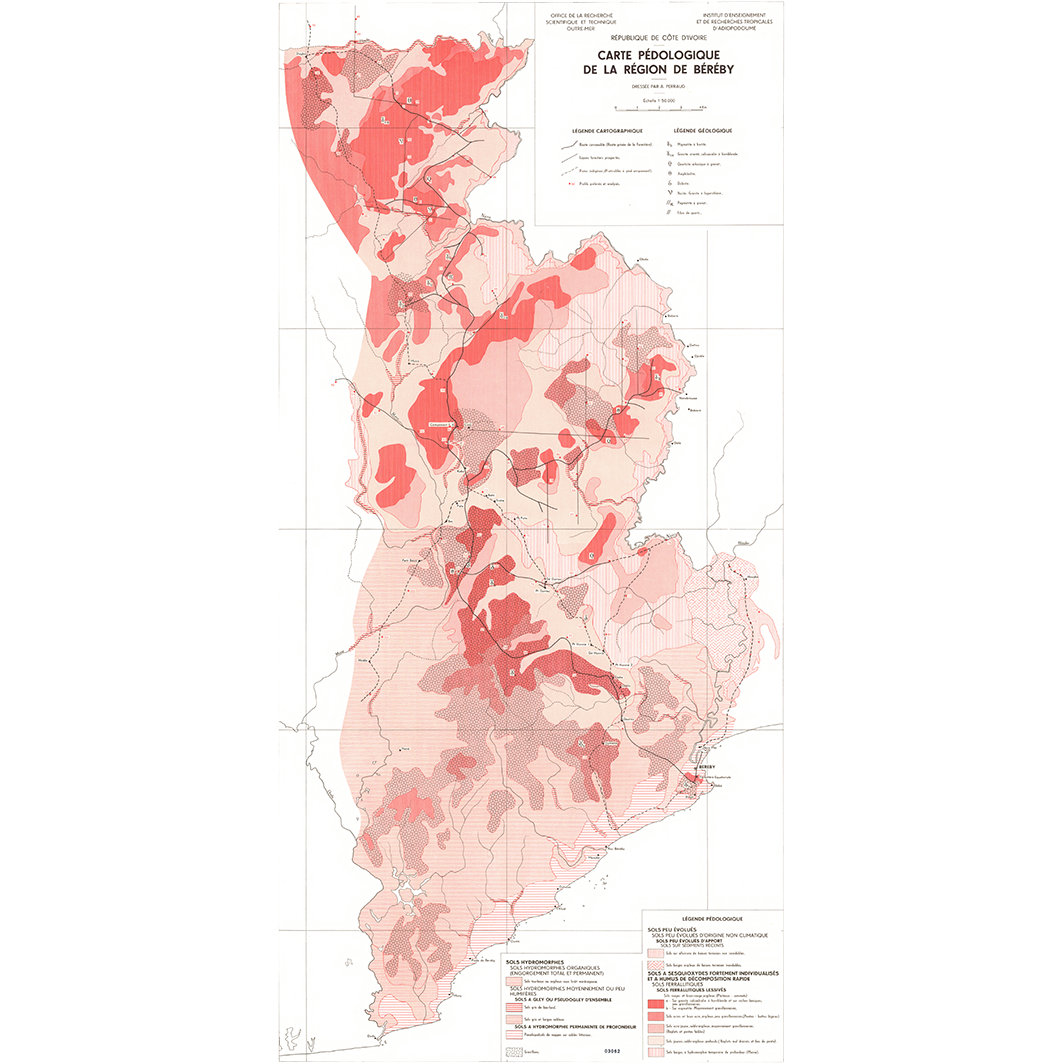
Carte pédologique de la région de Béréby, Sassandra - San-Pedro et du secteur Tabou - Olodio - Nidia. Scale of 1:50 000. Date of publication: 1962-1964.
1. Carte pédologique de la région de Béréby. / Perraud, A.; Dauteloup, J. (ill.); Scale of 1:50 000. Date of publication: 1962. (file: 03062RC_IRD_CIV_PEDO_1962_50000_IRD_CIV_PEDO_1962-64_50000.tif) 2. Carte pédologique de la région de Sassandra - San-Pedro : feuille 1. / Perraud, A.; Dauteloup, J. (ill.); Scale of 1:50 000. Date of publication: 1964. (file: 03067RC_IRD_CIV_PEDO_1964_50000_IRD_CIV_PEDO_1962-64_50000.tif) 3. Carte pédologique de la région de Sassandra - San-Pedro : feuille 2. / Perraud, A.; Dauteloup, J. (ill.); Scale of 1:50 000. Date of publication: 1964. (file: 03068RC_IRD_CIV_PEDO_1964_50000_IRD_CIV_PEDO_1962-64_50000.tif) 4. Carte pédologique du secteur Tabou - Olodio - Nidia. / Alboucq, G. (ill.); Pottier, J. C. (ill.); Alboucq, G. (ill.); Pottier, J. C. (ill.); Scale of 1:50 000. Date of publication: 1963. (file: 03065RC_IRD_CIV_PEDO_1963_50000_IRD_CIV_PEDO_1962-64_50000.tif)
Overview
Lineage
2. Georeferencing and if possible reprojection to WGS84 (Longitude / Latitude).
3. Clipping and mosaicing of map sheets(s).
4. Export ECW format.
5. ECW to GeoTIFF format conversion.
Links
Downloads
- sphaera_ws:03062RC_IRD_CIV_PEDO_1962_50000_IRD_CIV_PEDO_1962-64_50000 Carte pédologique de la région de Béréby.
- link
- sphaera_ws:03067RC_IRD_CIV_PEDO_1964_50000_IRD_CIV_PEDO_1962-64_50000 Carte pédologique de la région de Sassandra - San-Pedro : feuille 1.
- Télécharger au format GeoTIFF Télécharger au format GeoTIFF
- sphaera_ws:03068RC_IRD_CIV_PEDO_1964_50000_IRD_CIV_PEDO_1962-64_50000 Carte pédologique de la région de Sassandra - San-Pedro : feuille 2.
- Télécharger au format GeoTIFF Télécharger au format GeoTIFF
- sphaera_ws:03065RC_IRD_CIV_PEDO_1963_50000_IRD_CIV_PEDO_1962-64_50000 Carte pédologique du secteur Tabou - Olodio - Nidia.
- Télécharger au format GeoTIFF Télécharger au format GeoTIFF
Geolinks
- sphaera_ws:03062RC_IRD_CIV_PEDO_1962_50000_IRD_CIV_PEDO_1962-64_50000 Carte pédologique de la région de Béréby.
- sphaera_ws:03067RC_IRD_CIV_PEDO_1964_50000_IRD_CIV_PEDO_1962-64_50000 Carte pédologique de la région de Sassandra - San-Pedro : feuille 1.
- sphaera_ws:03068RC_IRD_CIV_PEDO_1964_50000_IRD_CIV_PEDO_1962-64_50000 Carte pédologique de la région de Sassandra - San-Pedro : feuille 2.
- sphaera_ws:03065RC_IRD_CIV_PEDO_1963_50000_IRD_CIV_PEDO_1962-64_50000 Carte pédologique du secteur Tabou - Olodio - Nidia.
Others
- Link to Original Record [datasuds-geo.ird.fr] This metadata comes from datasuds-geo.ird.fr
- Digital Object Identifier (DOI)