Le terroir de Tsarahonenana. Scale of 1:4 000 to 1:2 000. Date of publication: 1967.
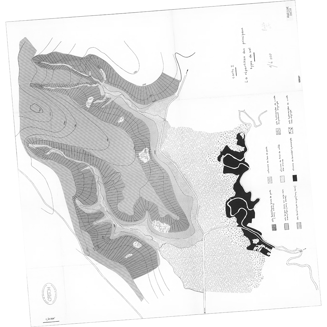
1. Carte 1 : la répartition des principaux types de sol. / Bonnemaison, Joël; Scale of 1:4 000. Date of publication: 1967. (file: 00637RC_IRD_MDG_PEDO_1967_4000_IRD_MDG_CSLO_1967_4000-2000.tif) 2. Carte 2 : la couverture végétale. / Bonnemaison, Joël; Scale of 1:4 000. Date of publication: 1967. (file: 00638RC_IRD_MDG_VEGE_1967_4000_IRD_MDG_CSLO_1967_4000-2000.tif) 3. Carte 3 : le paysage rural. / Bonnemaison, Joël; Scale of 1:2 000. Date of publication: 1967. (file: 00639RC_IRD_MDG_AGPA_1967_2000_IRD_MDG_CSLO_1967_4000-2000.tif) 4. Carte 4 : la distribution foncière des terres cultivées du terroir. / Bonnemaison, Joël; Scale of 1:4 000. Date of publication: 1967. (file: 00640RC_IRD_MDG_AGFN_1967_4000_IRD_MDG_CSLO_1967_4000-2000.tif) 5. Carte 5 : les régimes et le droit foncier. / Bonnemaison, Joël; Scale of 1:2 000. Date of publication: 1967. (file: 00641RC_IRD_MDG_AGFN_1967_2000_IRD_MDG_CSLO_1967_4000-2000.tif) 6. Carte 6 : structures foncières et liens de parenté : carte simplifiée. / Bonnemaison, Joël; Scale of 1:4 000. Date of publication: 1967. (file: 00642RC_IRD_MDG_AGFN_1967_4000_IRD_MDG_CSLO_1967_4000-2000.tif) 7. Carte 7 : les contrastes fonciers. / Bonnemaison, Joël; Scale of 1:4 000. Date of publication: 1967. (file: 00643RC_IRD_MDG_AGFN_1967_4000_IRD_MDG_CSLO_1967_4000-2000.tif) 8. Carte 8 : secteurs et types de cultures. / Bonnemaison, Joël; Scale of 1:2 000. Date of publication: 1967. (file: 00644RC_IRD_MDG_AGCU_1967_2000_IRD_MDG_CSLO_1967_4000-2000.tif)
Overview
Lineage
2. Georeferencing and if possible reprojection to WGS84 (Longitude / Latitude).
3. Clipping and mosaicing of map sheets(s).
4. Export ECW format.
5. ECW to GeoTIFF format conversion.
Links
Downloads
- sphaera_ws:00637RC_IRD_MDG_PEDO_1967_4000_IRD_MDG_CSLO_1967_4000-2000 Carte 1 : la répartition des principaux types de sol.
- link
- sphaera_ws:00638RC_IRD_MDG_VEGE_1967_4000_IRD_MDG_CSLO_1967_4000-2000 Carte 2 : la couverture végétale.
- Télécharger au format GeoTIFF Télécharger au format GeoTIFF
- sphaera_ws:00639RC_IRD_MDG_AGPA_1967_2000_IRD_MDG_CSLO_1967_4000-2000 Carte 3 : le paysage rural.
- Télécharger au format GeoTIFF Télécharger au format GeoTIFF
- sphaera_ws:00640RC_IRD_MDG_AGFN_1967_4000_IRD_MDG_CSLO_1967_4000-2000 Carte 4 : la distribution foncière des terres cultivées du terroir.
- Télécharger au format GeoTIFF Télécharger au format GeoTIFF
- sphaera_ws:00641RC_IRD_MDG_AGFN_1967_2000_IRD_MDG_CSLO_1967_4000-2000 Carte 5 : les régimes et le droit foncier.
- Télécharger au format GeoTIFF Télécharger au format GeoTIFF
- sphaera_ws:00642RC_IRD_MDG_AGFN_1967_4000_IRD_MDG_CSLO_1967_4000-2000 Carte 6 : structures foncières et liens de parenté : carte simplifiée.
- Télécharger au format GeoTIFF Télécharger au format GeoTIFF
- sphaera_ws:00643RC_IRD_MDG_AGFN_1967_4000_IRD_MDG_CSLO_1967_4000-2000 Carte 7 : les contrastes fonciers.
- Télécharger au format GeoTIFF Télécharger au format GeoTIFF
- sphaera_ws:00644RC_IRD_MDG_AGCU_1967_2000_IRD_MDG_CSLO_1967_4000-2000 Carte 8 : secteurs et types de cultures.
- Télécharger au format GeoTIFF Télécharger au format GeoTIFF
Geolinks
- sphaera_ws:00637RC_IRD_MDG_PEDO_1967_4000_IRD_MDG_CSLO_1967_4000-2000 Carte 1 : la répartition des principaux types de sol.
- sphaera_ws:00638RC_IRD_MDG_VEGE_1967_4000_IRD_MDG_CSLO_1967_4000-2000 Carte 2 : la couverture végétale.
- sphaera_ws:00639RC_IRD_MDG_AGPA_1967_2000_IRD_MDG_CSLO_1967_4000-2000 Carte 3 : le paysage rural.
- sphaera_ws:00640RC_IRD_MDG_AGFN_1967_4000_IRD_MDG_CSLO_1967_4000-2000 Carte 4 : la distribution foncière des terres cultivées du terroir.
- sphaera_ws:00641RC_IRD_MDG_AGFN_1967_2000_IRD_MDG_CSLO_1967_4000-2000 Carte 5 : les régimes et le droit foncier.
- sphaera_ws:00642RC_IRD_MDG_AGFN_1967_4000_IRD_MDG_CSLO_1967_4000-2000 Carte 6 : structures foncières et liens de parenté : carte simplifiée.
- sphaera_ws:00643RC_IRD_MDG_AGFN_1967_4000_IRD_MDG_CSLO_1967_4000-2000 Carte 7 : les contrastes fonciers.
- sphaera_ws:00644RC_IRD_MDG_AGCU_1967_2000_IRD_MDG_CSLO_1967_4000-2000 Carte 8 : secteurs et types de cultures.
Others
- Notice explicative ou autre ouvrage Document associé à la carte
- Link to Original Record [datasuds-geo.ird.fr] This metadata comes from datasuds-geo.ird.fr
- Notice explicative ou autre ouvrage Document associé à la carte
- Notice explicative ou autre ouvrage Document associé à la carte
- Notice explicative ou autre ouvrage Document associé à la carte
- Notice explicative ou autre ouvrage Document associé à la carte
- Notice explicative ou autre ouvrage Document associé à la carte
- Notice explicative ou autre ouvrage Document associé à la carte
- Notice explicative ou autre ouvrage Document associé à la carte
- Digital Object Identifier (DOI)