CATDS-CEC-SM L4 DI Monthly global drought indices obtained from SMOS' satellite root zone soil moisture
CATDS
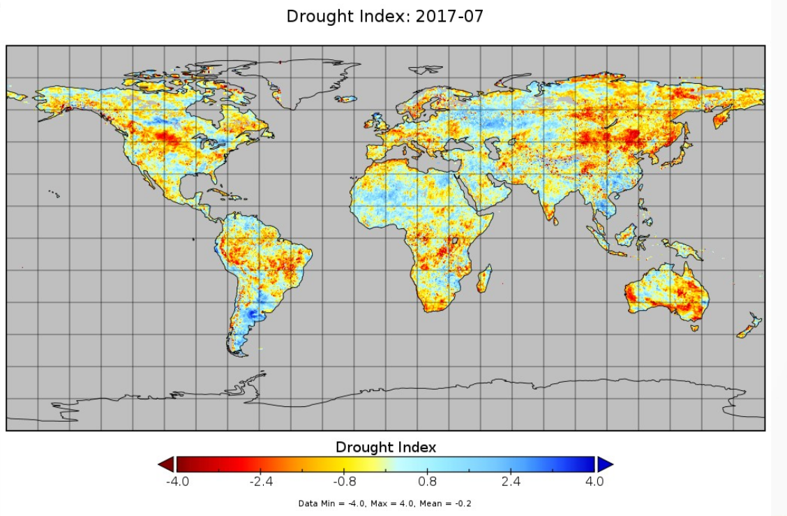
The drought index (DI) is computed using SMOS derived root zone soil moisture (RZSM) monthly fields. The concept is to consider 13 years of SMOS data (2010-2022). The RZSM monthly mean and max over the period is iused to compute a soil water deficit to remove seasonal variability. from teh soil water deficit a soil moisture drought index is computed .The range of values for SMDI lies between -4 to +4, with -4 representing extreme dry conditions and +4 representing extreme wet conditions.
publicationFeb 13, 2023creationJan 30, 2023
Temporal CoverageJan 1, 2010Dec 31, 2022
Overview
1 / 1
Lineage
Drought can be defined as the lower availability of water compared to the average water availability. Nowadays, drought is more frequent due to climate change, lack in precipitaion , heat waves etc. Drought can persist for days, weeks, months and even longer. Drought impacts the environment, economy, and society. Environmental effects include drying of wetlands, forest fires, loss of biodiversity, etc.; economic issues include loss of water supply, loss of agriculture, etc.; and social effects include the loss of food supply, direct effects on health due to heat waves, increase in food cost, water scarcity, etc.
Drought is generally categorized into three types: meteorological, hydrological, and agricultural drought. Meteorological drought can be defined as the condition when there is less precipitation than average over a long period. Hydrological drought is the condition when the availability of water reserves is below the normal threshold. Agricultural drought is the condition when there is a shortage of water for agriculture and crop yields are affected.
Agriculture drought is the most prominent sector affected by drought because of its dependence on water resources and the soil moisture reserve at various stages of plant growth. Agricultural droughts have a possible impact on food security in drought prone areas. The information about the agricultural drought can be useful for farming systems, irrigation and availability of the water resources.
The satellite based drought indices is very valuable, it can provide drought indices at a global spatial and temporal scale. The two main requirements to calculate agricultural drought indices- at a global scale- from satellite based information are: First, data about the availability of soil moisture at the root zone, and second, the presence data for a long period of time to account for the severity of the drought condition.
The main aim of this product is to make available a drought index generated from the SMOS level-4 Root Zone Soil Moisture product available on CATDS derived from the SMOS level-3 surface soil moisture. SMOS level-4 Root Zone Soil Moisture product provides root zone soil moisture data at a depth of (0-100) cm for the period of 2010-present.
Links
Downloads
- Http access
- FTP access FTP Access - All products are also available by ftp : server ftp.ifremer.fr, login ext-catds-cecsm, passwd catds2010, path Land_products/L4_Agricultural_Drought_Index
Geolinks
- No links available
Others
- Drought Index technical note the note describes the rationale and approach for the drought index product together with output format
- Link to Original Record [www.catds.fr] This metadata comes from www.catds.fr
- Digital Object Identifier (DOI)
Contacts
CESBIO (author)
CESBIO (principalInvestigator)
CATDS (publisher)
Keywords
Constraints
Copyright
Use limitations
CC-BY (Creative Commons - Attribution)