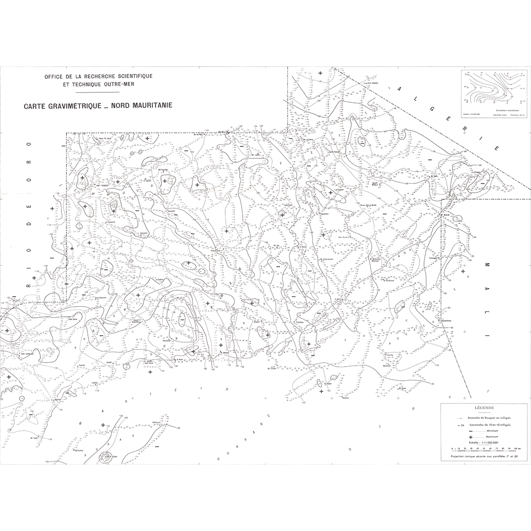
Carte gravimétrique et magnétiques: Nord Mauritanie et Mauritanie occidentale. Scale of 1:1 000 000. Date of publication: 1961-1962.
IDS IRD
1. Carte gravimétrique - Nord Mauritanie. / ORSTOM, Office de la recherche scientifique et technique outre-mer, Centre de géophysique; Scale of 1:1 000 000. Date of publication: 1961. (files: 00795RC_IRD_MRT_GPGR_1961_1000000-01_IRD_MRT_GPGR_1961-62_1000000.tif, 00795RC_IRD_MRT_GPGR_1961_1000000-02_IRD_MRT_GPGR_1961-62_1000000.tif) 2. Carte gravimétrique, Mauritanie occidentale. / Buffard Morel, J. M. (ill.); Scale of 1:1 000 000. Date of publication: 1962. (files: 01645RC_IRD_MRT_GPGR_1962_1000000-01_IRD_MRT_GPGR_1961-62_1000000.tif, 01645RC_IRD_MRT_GPGR_1962_1000000-02_IRD_MRT_GPGR_1961-62_1000000.tif)
publicationDec 31, 1960
Temporal CoverageJan 1, 1961Dec 31, 1962
Overview
1 / 6
Lineage
1. Scanning to tif format, 256 colors, 250dpi.
2. Georeferencing and if possible reprojection to WGS84 (Longitude / Latitude).
3. Clipping and mosaicing of map sheets(s).
4. Export ECW format.
5. ECW to GeoTIFF format conversion.
2. Georeferencing and if possible reprojection to WGS84 (Longitude / Latitude).
3. Clipping and mosaicing of map sheets(s).
4. Export ECW format.
5. ECW to GeoTIFF format conversion.
Links
Downloads
- sphaera_ws:00795RC_IRD_MRT_GPGR_1961_1000000-01_IRD_MRT_GPGR_1961-62_1000000 Carte gravimétrique - Nord Mauritanie.
- link
- sphaera_ws:00795RC_IRD_MRT_GPGR_1961_1000000-02_IRD_MRT_GPGR_1961-62_1000000 Carte gravimétrique - Nord Mauritanie.
- Télécharger au format GeoTIFF Télécharger au format GeoTIFF
- sphaera_ws:01645RC_IRD_MRT_GPGR_1962_1000000-01_IRD_MRT_GPGR_1961-62_1000000 Carte gravimétrique, Mauritanie occidentale.
- Télécharger au format GeoTIFF Télécharger au format GeoTIFF
- sphaera_ws:01645RC_IRD_MRT_GPGR_1962_1000000-02_IRD_MRT_GPGR_1961-62_1000000 Carte gravimétrique, Mauritanie occidentale.
- Télécharger au format GeoTIFF Télécharger au format GeoTIFF
Geolinks
- sphaera_ws:00795RC_IRD_MRT_GPGR_1961_1000000-01_IRD_MRT_GPGR_1961-62_1000000 Carte gravimétrique - Nord Mauritanie.
- sphaera_ws:00795RC_IRD_MRT_GPGR_1961_1000000-02_IRD_MRT_GPGR_1961-62_1000000 Carte gravimétrique - Nord Mauritanie.
- sphaera_ws:01645RC_IRD_MRT_GPGR_1962_1000000-01_IRD_MRT_GPGR_1961-62_1000000 Carte gravimétrique, Mauritanie occidentale.
- sphaera_ws:01645RC_IRD_MRT_GPGR_1962_1000000-02_IRD_MRT_GPGR_1961-62_1000000 Carte gravimétrique, Mauritanie occidentale.
Others
- Notice explicative ou autre ouvrage Document associé à la carte
- Link to Original Record [datasuds-geo.ird.fr] This metadata comes from datasuds-geo.ird.fr
- Notice explicative ou autre ouvrage Document associé à la carte
- Notice explicative ou autre ouvrage Document associé à la carte
- Notice explicative ou autre ouvrage Document associé à la carte
- Digital Object Identifier (DOI)
Keywords
Constraints
licence
Use limitations
Licence : CC-BY-NC-SA