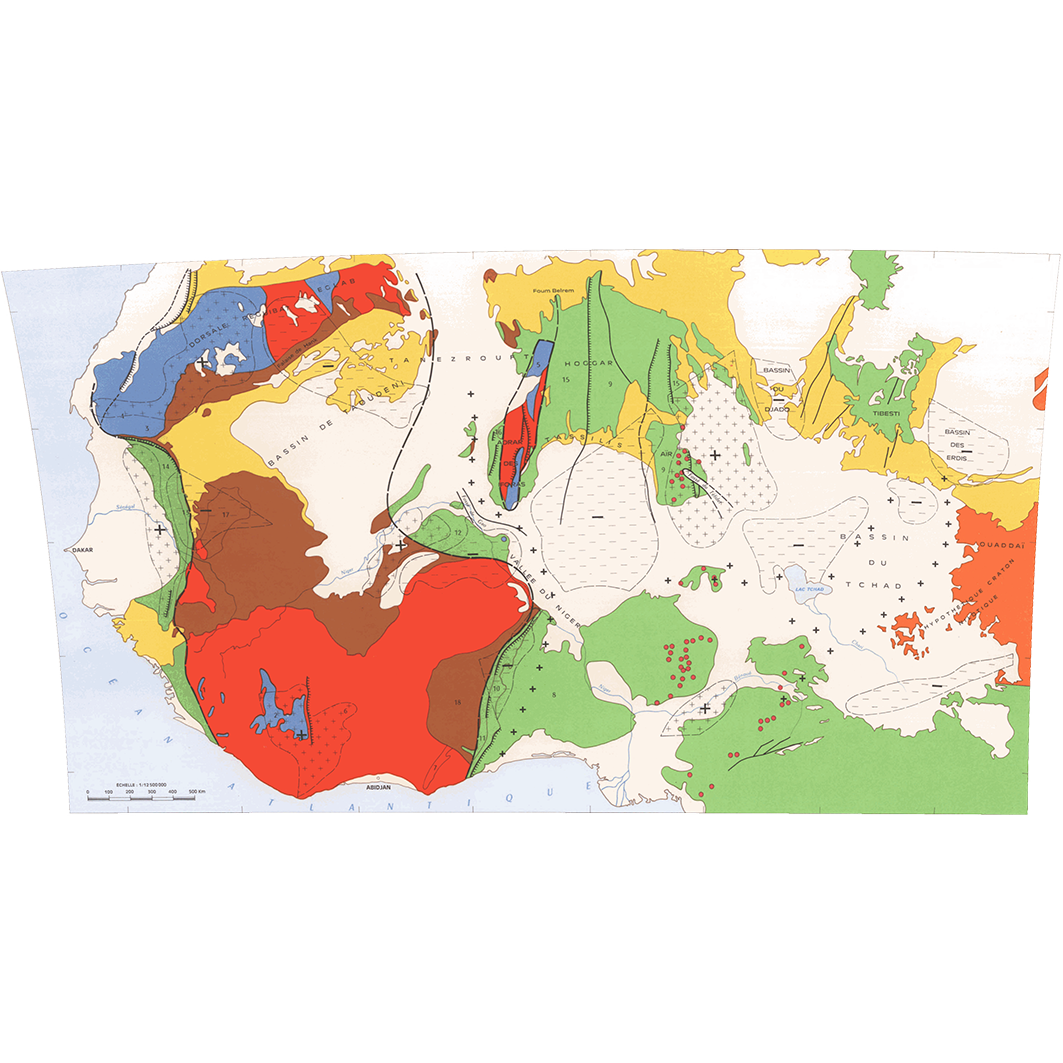
Schéma gravimétrique de l'Afrique occidentale et centrale. Scale of 1:12 500 000 to 1:2 000 000. Date of publication: 1969.
1. Esquisse structurale de l'Afrique occidentale et centrale - Géologie et gravimétrie du Massif Central Tchadien. / ORSTOM, Office de la recherche scientifique et technique outre-mer, Service cartographique; Scale of 1:12 500 000 to 1:2 000 000. Date of publication: 1969. (files: 11275RC_IRD_-AF_GEOL_1969_12500000_IRD_-AF_GEOL_1969_12500000-2000000.tif, 11275RC_IRD_-AF_GEOL_1969_2000000_IRD_-AF_GEOL_1969_12500000-2000000.tif) 2. Géologie et géophysique du Ténéré - Géologie et géophysique des régions situées au nord du lac - Schéma gravimétrique de l'Afrique occidentale et centrale : limites du craton ouest-africain - Géologie et géophysique du Tchad méridional. / Buffard Morel, J. M.; Scale of 1:12 500 000 to 1:2 000 000. Date of publication: 1969. (files: 11276RC_IRD_-AF_GEOL_1969_12500000_IRD_-AF_GEOL_1969_12500000-2000000.tif, 11276RC_IRD_-AF_GEOL_1969_2000000-01_IRD_-AF_GEOL_1969_12500000-2000000.tif, 11276RC_IRD_-AF_GEOL_1969_2000000-02_IRD_-AF_GEOL_1969_12500000-2000000.tif, 11276RC_IRD_-AF_GEOL_1969_2000000-03_IRD_-AF_GEOL_1969_12500000-2000000.tif)
Overview
Lineage
2. Georeferencing and if possible reprojection to WGS84 (Longitude / Latitude).
3. Clipping and mosaicing of map sheets(s).
4. Export ECW format.
5. ECW to GeoTIFF format conversion.
Links
Downloads
- sphaera_ws:11275RC_IRD_-AF_GEOL_1969_12500000_IRD_-AF_GEOL_1969_12500000-2000000 Esquisse structurale de l'Afrique occidentale et centrale - Géologie et gravimétrie du Massif Central Tchadien.
- link
- sphaera_ws:11275RC_IRD_-AF_GEOL_1969_2000000_IRD_-AF_GEOL_1969_12500000-2000000 Esquisse structurale de l'Afrique occidentale et centrale - Géologie et gravimétrie du Massif Central Tchadien.
- Télécharger au format GeoTIFF Télécharger au format GeoTIFF
- sphaera_ws:11276RC_IRD_-AF_GEOL_1969_12500000_IRD_-AF_GEOL_1969_12500000-2000000 Géologie et géophysique du Ténéré - Géologie et géophysique des régions situées au nord du lac - Schéma gravimétrique de l'Afrique occidentale et centrale : limites du craton ouest-africain - Géologie et géophysique du Tchad méridional.
- Télécharger au format GeoTIFF Télécharger au format GeoTIFF
- sphaera_ws:11276RC_IRD_-AF_GEOL_1969_2000000-01_IRD_-AF_GEOL_1969_12500000-2000000 Géologie et géophysique du Ténéré - Géologie et géophysique des régions situées au nord du lac - Schéma gravimétrique de l'Afrique occidentale et centrale : limites du craton ouest-africain - Géologie et géophysique du Tchad méridional.
- Télécharger au format GeoTIFF Télécharger au format GeoTIFF
- sphaera_ws:11276RC_IRD_-AF_GEOL_1969_2000000-02_IRD_-AF_GEOL_1969_12500000-2000000 Géologie et géophysique du Ténéré - Géologie et géophysique des régions situées au nord du lac - Schéma gravimétrique de l'Afrique occidentale et centrale : limites du craton ouest-africain - Géologie et géophysique du Tchad méridional.
- Télécharger au format GeoTIFF Télécharger au format GeoTIFF
- sphaera_ws:11276RC_IRD_-AF_GEOL_1969_2000000-03_IRD_-AF_GEOL_1969_12500000-2000000 Géologie et géophysique du Ténéré - Géologie et géophysique des régions situées au nord du lac - Schéma gravimétrique de l'Afrique occidentale et centrale : limites du craton ouest-africain - Géologie et géophysique du Tchad méridional.
- Télécharger au format GeoTIFF Télécharger au format GeoTIFF
Geolinks
- sphaera_ws:11275RC_IRD_-AF_GEOL_1969_12500000_IRD_-AF_GEOL_1969_12500000-2000000 Esquisse structurale de l'Afrique occidentale et centrale - Géologie et gravimétrie du Massif Central Tchadien.
- sphaera_ws:11275RC_IRD_-AF_GEOL_1969_2000000_IRD_-AF_GEOL_1969_12500000-2000000 Esquisse structurale de l'Afrique occidentale et centrale - Géologie et gravimétrie du Massif Central Tchadien.
- sphaera_ws:11276RC_IRD_-AF_GEOL_1969_12500000_IRD_-AF_GEOL_1969_12500000-2000000 Géologie et géophysique du Ténéré - Géologie et géophysique des régions situées au nord du lac - Schéma gravimétrique de l'Afrique occidentale et centrale : limites du craton ouest-africain - Géologie et géophysique du Tchad méridional.
- sphaera_ws:11276RC_IRD_-AF_GEOL_1969_2000000-01_IRD_-AF_GEOL_1969_12500000-2000000 Géologie et géophysique du Ténéré - Géologie et géophysique des régions situées au nord du lac - Schéma gravimétrique de l'Afrique occidentale et centrale : limites du craton ouest-africain - Géologie et géophysique du Tchad méridional.
- sphaera_ws:11276RC_IRD_-AF_GEOL_1969_2000000-02_IRD_-AF_GEOL_1969_12500000-2000000 Géologie et géophysique du Ténéré - Géologie et géophysique des régions situées au nord du lac - Schéma gravimétrique de l'Afrique occidentale et centrale : limites du craton ouest-africain - Géologie et géophysique du Tchad méridional.
- sphaera_ws:11276RC_IRD_-AF_GEOL_1969_2000000-03_IRD_-AF_GEOL_1969_12500000-2000000 Géologie et géophysique du Ténéré - Géologie et géophysique des régions situées au nord du lac - Schéma gravimétrique de l'Afrique occidentale et centrale : limites du craton ouest-africain - Géologie et géophysique du Tchad méridional.
Others
- Link to Original Record [datasuds-geo.ird.fr] This metadata comes from datasuds-geo.ird.fr
- Digital Object Identifier (DOI)