La pêche dans le delta central du Niger : approche pluridisciplinaire d'un système de production halieutique. Scale of 1:500 000. Date of publication: 1994.
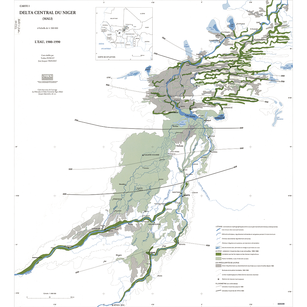
1. Carte 1 : l'eau, 1980 -1990. / Poncet, Yvelyne; Auberton, E. (ill.); Bertrand, S. (ill.); Quensière, Jacques (éd. scientifique); Troubat, Jean Jacques; Valton, C. (ill.); Scale of 1:500 000. Date of publication: 1994. (file: 00539RC_IRD_MLI_HYGR_1994_500000_IRD_MLI_CSRE_1994_500000.tif) 2. Carte 2 : croquis morpho-pédologique. / Poncet, Yvelyne; Auberton, E. (ill.); Bertrand, S. (ill.); Quensière, Jacques (éd. scientifique); Troubat, Jean Jacques; Valton, C. (ill.); Scale of 1:500 000. Date of publication: 1994. (file: 00543RC_IRD_MLI_PEMP_1994_500000_IRD_MLI_CSRE_1994_500000.tif) 3. Carte 3 : répartition de la population recensée, 1987. / Poncet, Yvelyne; Auberton, E. (ill.); Bertrand, S. (ill.); Quensière, Jacques (éd. scientifique); Raffray, Jean; Troubat, Jean Jacques; Valton, C. (ill.); Scale of 1:500 000. Date of publication: 1994. (file: 00544RC_IRD_MLI_PODE_1994_500000_IRD_MLI_CSRE_1994_500000.tif) 4. Carte 4 : les pêcheurs et la pêche. / Poncet, Yvelyne; Auberton, E. (ill.); Bertrand, S. (ill.); Quensière, Jacques (éd. scientifique); Raffray, Jean; Troubat, Jean Jacques; Valton, C. (ill.); Scale of 1:500 000. Date of publication: 1994. (file: 00545RC_IRD_MLI_AGPE_1994_500000_IRD_MLI_CSRE_1994_500000.tif) 5. Carte 5 : emprise agricole et pastorale. / Poncet, Yvelyne; Auberton, E. (ill.); Bertrand, S. (ill.); Quensière, Jacques (éd. scientifique); Troubat, Jean Jacques; Valton, C. (ill.); Scale of 1:500 000. Date of publication: 1994. (file: 00546RC_IRD_MLI_AGRO_1994_500000_IRD_MLI_CSRE_1994_500000.tif) 6. Carte 6 : communications et marchés. / Poncet, Yvelyne; Auberton, E. (ill.); Bertrand, S. (ill.); Quensière, Jacques (éd. scientifique); Troubat, Jean Jacques; Valton, C. (ill.); Scale of 1:500 000. Date of publication: 1994. (file: 00547RC_IRD_MLI_INFR_1994_500000_IRD_MLI_CSRE_1994_500000.tif) 7. Carte 7 : l'histoire du peuplement et la structuration du delta. / Poncet, Yvelyne; Auberton, E. (ill.); Bertrand, S. (ill.); Quensière, Jacques (éd. scientifique); Troubat, Jean Jacques; Valton, C. (ill.); Scale of 1:500 000. Date of publication: 1994. (file: 00548RC_IRD_MLI_POPE_1994_500000_IRD_MLI_CSRE_1994_500000.tif) 8. Carte 8 : les changements dans le delta central. / Poncet, Yvelyne; Auberton, E. (ill.); Bertrand, S. (ill.); Quensière, Jacques (éd. scientifique); Troubat, Jean Jacques; Valton, C. (ill.); Scale of 1:500 000. Date of publication: 1994. (file: 00549RC_IRD_MLI_USOL_1994_500000_IRD_MLI_CSRE_1994_500000.tif)
Overview
Lineage
2. Georeferencing and if possible reprojection to WGS84 (Longitude / Latitude).
3. Clipping and mosaicing of map sheets(s).
4. Export ECW format.
5. ECW to GeoTIFF format conversion.
Links
Downloads
- sphaera_ws:00539RC_IRD_MLI_HYGR_1994_500000_IRD_MLI_CSRE_1994_500000 Carte 1 : l'eau, 1980 -1990.
- link
- sphaera_ws:00543RC_IRD_MLI_PEMP_1994_500000_IRD_MLI_CSRE_1994_500000 Carte 2 : croquis morpho-pédologique.
- Télécharger au format GeoTIFF Télécharger au format GeoTIFF
- sphaera_ws:00544RC_IRD_MLI_PODE_1994_500000_IRD_MLI_CSRE_1994_500000 Carte 3 : répartition de la population recensée, 1987.
- Télécharger au format GeoTIFF Télécharger au format GeoTIFF
- sphaera_ws:00545RC_IRD_MLI_AGPE_1994_500000_IRD_MLI_CSRE_1994_500000 Carte 4 : les pêcheurs et la pêche.
- Télécharger au format GeoTIFF Télécharger au format GeoTIFF
- sphaera_ws:00546RC_IRD_MLI_AGRO_1994_500000_IRD_MLI_CSRE_1994_500000 Carte 5 : emprise agricole et pastorale.
- Télécharger au format GeoTIFF Télécharger au format GeoTIFF
- sphaera_ws:00547RC_IRD_MLI_INFR_1994_500000_IRD_MLI_CSRE_1994_500000 Carte 6 : communications et marchés.
- Télécharger au format GeoTIFF Télécharger au format GeoTIFF
- sphaera_ws:00548RC_IRD_MLI_POPE_1994_500000_IRD_MLI_CSRE_1994_500000 Carte 7 : l'histoire du peuplement et la structuration du delta.
- Télécharger au format GeoTIFF Télécharger au format GeoTIFF
- sphaera_ws:00549RC_IRD_MLI_USOL_1994_500000_IRD_MLI_CSRE_1994_500000 Carte 8 : les changements dans le delta central.
- Télécharger au format GeoTIFF Télécharger au format GeoTIFF
Geolinks
- sphaera_ws:00539RC_IRD_MLI_HYGR_1994_500000_IRD_MLI_CSRE_1994_500000 Carte 1 : l'eau, 1980 -1990.
- sphaera_ws:00543RC_IRD_MLI_PEMP_1994_500000_IRD_MLI_CSRE_1994_500000 Carte 2 : croquis morpho-pédologique.
- sphaera_ws:00544RC_IRD_MLI_PODE_1994_500000_IRD_MLI_CSRE_1994_500000 Carte 3 : répartition de la population recensée, 1987.
- sphaera_ws:00545RC_IRD_MLI_AGPE_1994_500000_IRD_MLI_CSRE_1994_500000 Carte 4 : les pêcheurs et la pêche.
- sphaera_ws:00546RC_IRD_MLI_AGRO_1994_500000_IRD_MLI_CSRE_1994_500000 Carte 5 : emprise agricole et pastorale.
- sphaera_ws:00547RC_IRD_MLI_INFR_1994_500000_IRD_MLI_CSRE_1994_500000 Carte 6 : communications et marchés.
- sphaera_ws:00548RC_IRD_MLI_POPE_1994_500000_IRD_MLI_CSRE_1994_500000 Carte 7 : l'histoire du peuplement et la structuration du delta.
- sphaera_ws:00549RC_IRD_MLI_USOL_1994_500000_IRD_MLI_CSRE_1994_500000 Carte 8 : les changements dans le delta central.
Others
- Notice explicative ou autre ouvrage Document associé à la carte
- Link to Original Record [datasuds-geo.ird.fr] This metadata comes from datasuds-geo.ird.fr
- Notice explicative ou autre ouvrage Document associé à la carte
- Notice explicative ou autre ouvrage Document associé à la carte
- Notice explicative ou autre ouvrage Document associé à la carte
- Notice explicative ou autre ouvrage Document associé à la carte
- Notice explicative ou autre ouvrage Document associé à la carte
- Notice explicative ou autre ouvrage Document associé à la carte
- Notice explicative ou autre ouvrage Document associé à la carte
- Digital Object Identifier (DOI)