Carte sédimentologique du Plateau Continental Mauritanien. Scale of 1:1 000 000 to 1:200 000. Date of publication: 1985.
IDS IRD
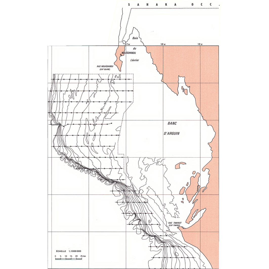
1. Nouadhibou : carte sédimentologique du Plateau Continental Mauritanien. / Domain, F.; Deruelle, R. (ill.); Weiss Michoux, S. (collab.) Scale of 1:1 000 000 to 1:200 000. Date of publication: 1985. (files: 01041RC_IRD_MRT_SEPC_1985_1000000_IRD_MRT_SEPC_1985_1000000-200000.tif, 01041RC_IRD_MRT_SEPC_1985_200000_IRD_MRT_SEPC_1985_1000000-200000.tif) 2. Nouakchott : carte sédimentologique du Plateau Continental Mauritanien. / Domain, F.; Deruelle, R. (ill.); Weiss Michoux, S. (collab.) Scale of 1:1 000 000 to 1:200 000. Date of publication: 1985. (files: 01042RC_IRD_MRT_SEPC_1985_1000000_IRD_MRT_SEPC_1985_1000000-200000.tif, 01042RC_IRD_MRT_SEPC_1985_200000_IRD_MRT_SEPC_1985_1000000-200000.tif)
publicationDec 31, 1984
Temporal CoverageJan 1, 1985Dec 31, 1985
Overview
1 / 6
Lineage
1. Scanning to tif format, 256 colors, 250dpi.
2. Georeferencing and if possible reprojection to WGS84 (Longitude / Latitude).
3. Clipping and mosaicing of map sheets(s).
4. Export ECW format.
5. ECW to GeoTIFF format conversion.
2. Georeferencing and if possible reprojection to WGS84 (Longitude / Latitude).
3. Clipping and mosaicing of map sheets(s).
4. Export ECW format.
5. ECW to GeoTIFF format conversion.
Links
Downloads
- sphaera_ws:01041RC_IRD_MRT_SEPC_1985_1000000_IRD_MRT_SEPC_1985_1000000-200000 Nouadhibou : carte sédimentologique du Plateau Continental Mauritanien.
- link
- sphaera_ws:01041RC_IRD_MRT_SEPC_1985_200000_IRD_MRT_SEPC_1985_1000000-200000 Nouadhibou : carte sédimentologique du Plateau Continental Mauritanien.
- Télécharger au format GeoTIFF Télécharger au format GeoTIFF
- sphaera_ws:01042RC_IRD_MRT_SEPC_1985_1000000_IRD_MRT_SEPC_1985_1000000-200000 Nouakchott : carte sédimentologique du Plateau Continental Mauritanien.
- Télécharger au format GeoTIFF Télécharger au format GeoTIFF
- sphaera_ws:01042RC_IRD_MRT_SEPC_1985_200000_IRD_MRT_SEPC_1985_1000000-200000 Nouakchott : carte sédimentologique du Plateau Continental Mauritanien.
- Télécharger au format GeoTIFF Télécharger au format GeoTIFF
Geolinks
- sphaera_ws:01041RC_IRD_MRT_SEPC_1985_1000000_IRD_MRT_SEPC_1985_1000000-200000 Nouadhibou : carte sédimentologique du Plateau Continental Mauritanien.
- sphaera_ws:01041RC_IRD_MRT_SEPC_1985_200000_IRD_MRT_SEPC_1985_1000000-200000 Nouadhibou : carte sédimentologique du Plateau Continental Mauritanien.
- sphaera_ws:01042RC_IRD_MRT_SEPC_1985_1000000_IRD_MRT_SEPC_1985_1000000-200000 Nouakchott : carte sédimentologique du Plateau Continental Mauritanien.
- sphaera_ws:01042RC_IRD_MRT_SEPC_1985_200000_IRD_MRT_SEPC_1985_1000000-200000 Nouakchott : carte sédimentologique du Plateau Continental Mauritanien.
Others
- Notice explicative ou autre ouvrage Document associé à la carte
- Link to Original Record [datasuds-geo.ird.fr] This metadata comes from datasuds-geo.ird.fr
- Notice explicative ou autre ouvrage Document associé à la carte
- Notice explicative ou autre ouvrage Document associé à la carte
- Notice explicative ou autre ouvrage Document associé à la carte
- Digital Object Identifier (DOI)
Keywords
Constraints
licence
Use limitations
Licence : CC-BY-NC-SA