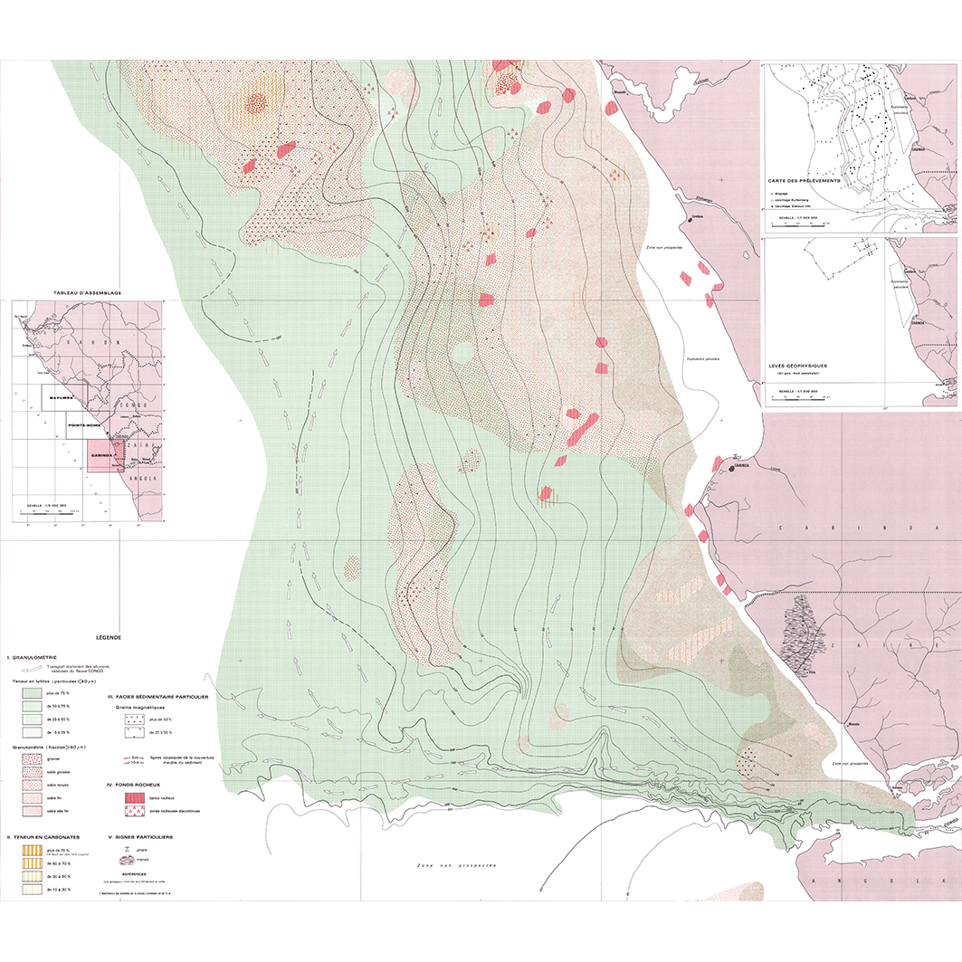
Carte sédimentologique du plateau continental du Congo. Scale of 1:200 000. Date of publication: 1980.
1. Carte sédimentologique du plateau continental du Congo : Cabinda. / Giresse, P.; Douib, A. (ill.); Kouyoumontzakis, G. (collab.); Moguedet, G. (collab.) Scale of 1:200 000. Date of publication: 1980. (files: 02998RC_IRD_COG_SEPC_1980_200000-01_IRD_COG_SEPC_1980_200000.tif, 02998RC_IRD_COG_SEPC_1980_200000-02_IRD_COG_SEPC_1980_200000.tif, 02998RC_IRD_COG_SEPC_1980_200000-03_IRD_COG_SEPC_1980_200000.tif) 2. Carte sédimentologique du plateau continental du Congo : Mayumba. / Giresse, P.; Douib, A. (ill.); Kouyoumontzakis, G. (collab.); Moguedet, G. (collab.) Scale of 1:200 000. Date of publication: 1980. (files: 02997RC_IRD_COG_SEPC_1980_200000-01_IRD_COG_SEPC_1980_200000.tif, 02997RC_IRD_COG_SEPC_1980_200000-02_IRD_COG_SEPC_1980_200000.tif, 02997RC_IRD_COG_SEPC_1980_200000-03_IRD_COG_SEPC_1980_200000.tif) 3. Carte sédimentologique du plateau continental du Congo : Pointe-Noire. / Giresse, P.; Douib, A. (ill.); Kouyoumontzakis, G. (collab.); Moguedet, G. (collab.) Scale of 1:200 000. Date of publication: 1980. (files: 02999RC_IRD_COG_SEPC_1980_200000-01_IRD_COG_SEPC_1980_200000.tif, 02999RC_IRD_COG_SEPC_1980_200000-02_IRD_COG_SEPC_1980_200000.tif, 02999RC_IRD_COG_SEPC_1980_200000-03_IRD_COG_SEPC_1980_200000.tif)
Overview
Lineage
2. Georeferencing and if possible reprojection to WGS84 (Longitude / Latitude).
3. Clipping and mosaicing of map sheets(s).
4. Export ECW format.
5. ECW to GeoTIFF format conversion.
Links
Downloads
- sphaera_ws:02998RC_IRD_COG_SEPC_1980_200000-01_IRD_COG_SEPC_1980_200000 Carte sédimentologique du plateau continental du Congo : Cabinda.
- link
- sphaera_ws:02998RC_IRD_COG_SEPC_1980_200000-02_IRD_COG_SEPC_1980_200000 Carte sédimentologique du plateau continental du Congo : Cabinda.
- Télécharger au format GeoTIFF Télécharger au format GeoTIFF
- sphaera_ws:02998RC_IRD_COG_SEPC_1980_200000-03_IRD_COG_SEPC_1980_200000 Carte sédimentologique du plateau continental du Congo : Cabinda.
- Télécharger au format GeoTIFF Télécharger au format GeoTIFF
- sphaera_ws:02997RC_IRD_COG_SEPC_1980_200000-01_IRD_COG_SEPC_1980_200000 Carte sédimentologique du plateau continental du Congo : Mayumba.
- Télécharger au format GeoTIFF Télécharger au format GeoTIFF
- sphaera_ws:02997RC_IRD_COG_SEPC_1980_200000-02_IRD_COG_SEPC_1980_200000 Carte sédimentologique du plateau continental du Congo : Mayumba.
- Télécharger au format GeoTIFF Télécharger au format GeoTIFF
- sphaera_ws:02997RC_IRD_COG_SEPC_1980_200000-03_IRD_COG_SEPC_1980_200000 Carte sédimentologique du plateau continental du Congo : Mayumba.
- Télécharger au format GeoTIFF Télécharger au format GeoTIFF
- sphaera_ws:02999RC_IRD_COG_SEPC_1980_200000-01_IRD_COG_SEPC_1980_200000 Carte sédimentologique du plateau continental du Congo : Pointe-Noire.
- Télécharger au format GeoTIFF Télécharger au format GeoTIFF
- sphaera_ws:02999RC_IRD_COG_SEPC_1980_200000-02_IRD_COG_SEPC_1980_200000 Carte sédimentologique du plateau continental du Congo : Pointe-Noire.
- Télécharger au format GeoTIFF Télécharger au format GeoTIFF
- sphaera_ws:02999RC_IRD_COG_SEPC_1980_200000-03_IRD_COG_SEPC_1980_200000 Carte sédimentologique du plateau continental du Congo : Pointe-Noire.
- Télécharger au format GeoTIFF Télécharger au format GeoTIFF
Geolinks
- sphaera_ws:02998RC_IRD_COG_SEPC_1980_200000-01_IRD_COG_SEPC_1980_200000 Carte sédimentologique du plateau continental du Congo : Cabinda.
- sphaera_ws:02998RC_IRD_COG_SEPC_1980_200000-02_IRD_COG_SEPC_1980_200000 Carte sédimentologique du plateau continental du Congo : Cabinda.
- sphaera_ws:02998RC_IRD_COG_SEPC_1980_200000-03_IRD_COG_SEPC_1980_200000 Carte sédimentologique du plateau continental du Congo : Cabinda.
- sphaera_ws:02997RC_IRD_COG_SEPC_1980_200000-01_IRD_COG_SEPC_1980_200000 Carte sédimentologique du plateau continental du Congo : Mayumba.
- sphaera_ws:02997RC_IRD_COG_SEPC_1980_200000-02_IRD_COG_SEPC_1980_200000 Carte sédimentologique du plateau continental du Congo : Mayumba.
- sphaera_ws:02997RC_IRD_COG_SEPC_1980_200000-03_IRD_COG_SEPC_1980_200000 Carte sédimentologique du plateau continental du Congo : Mayumba.
- sphaera_ws:02999RC_IRD_COG_SEPC_1980_200000-01_IRD_COG_SEPC_1980_200000 Carte sédimentologique du plateau continental du Congo : Pointe-Noire.
- sphaera_ws:02999RC_IRD_COG_SEPC_1980_200000-02_IRD_COG_SEPC_1980_200000 Carte sédimentologique du plateau continental du Congo : Pointe-Noire.
- sphaera_ws:02999RC_IRD_COG_SEPC_1980_200000-03_IRD_COG_SEPC_1980_200000 Carte sédimentologique du plateau continental du Congo : Pointe-Noire.
Others
- Notice explicative ou autre ouvrage Document associé à la carte
- Link to Original Record [datasuds-geo.ird.fr] This metadata comes from datasuds-geo.ird.fr
- Notice explicative ou autre ouvrage Document associé à la carte
- Notice explicative ou autre ouvrage Document associé à la carte
- Notice explicative ou autre ouvrage Document associé à la carte
- Notice explicative ou autre ouvrage Document associé à la carte
- Notice explicative ou autre ouvrage Document associé à la carte
- Notice explicative ou autre ouvrage Document associé à la carte
- Notice explicative ou autre ouvrage Document associé à la carte
- Notice explicative ou autre ouvrage Document associé à la carte
- Digital Object Identifier (DOI)