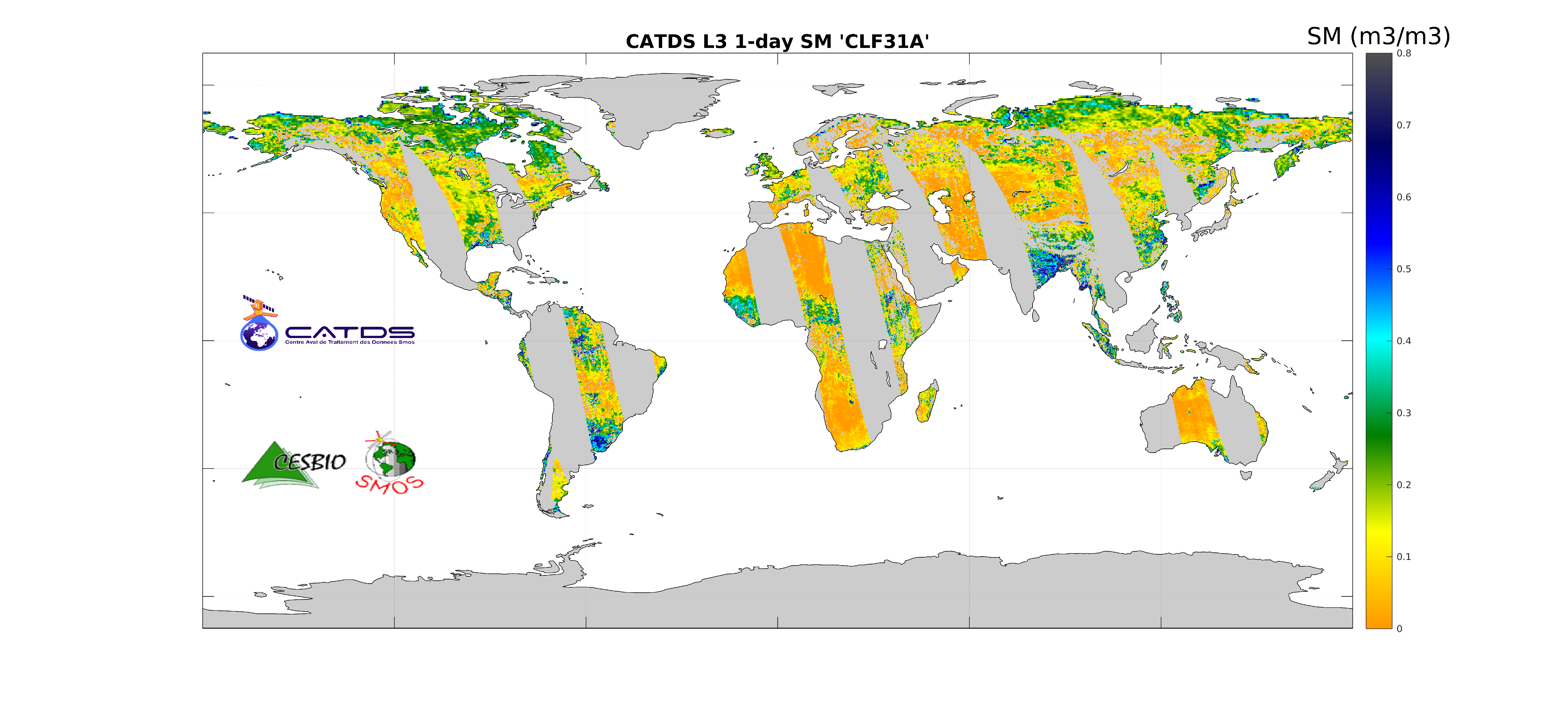
CATDS-PDC L3SM Filtered - 1 day global map of soil moisture values from SMOS satellite
CATDS
This product is the daily product of soil moisture, and contains filtered data. The retrievals are based on a multi-orbit retrieval algorithm. A detection of freeze and snow is performed and added to the flags. Ascending and descending orbits are processed separately.
publicationFeb 13, 2022
Temporal CoverageJan 12, 2010
Overview
1 / 1
Lineage
The base products, for all the CATDS-PDC (Centre Aval de Traitement des Données SMOS - Production & Dissemination Center) processing chains, are the SMOS L1B products - https://doi.org/10.57780/SM1-e20cf57 - from ESA (European Space Agency).
The L3SM filtered product is the daily product of soil moisture, and contains filtered data. The retrievals are based on a multi-orbit retrieval algorithm. A detection of freeze and snow is performed and added to the flags. Ascending and descending orbits are processed separately. The aggregated products are generated from this fundamental product.
Products from reprocessing RE07 are available for the period 01/2010 - 05/2021. Products from operational (OPER) processing are available since 06/2021. Reprocessed products and operational products are derived using the same algorithm and configuration, hence ensuring the temporal continuity.
File naming :
SM_clas_MIR_CLF31x_startdate_enddate_vvv_ccc_7
- clas : File class (OPER : operational mode, REXX : reprocessing xx)
- x : A for ascending orbit, D for descending orbit
- startdate : sensing start date/time of the data (format yyyymmddThhmiss)
- enddate : sensing end date/time of the data (format yyyymmddThhmiss)
- vvv : version number of the processor generating the product
- ccc : file counter
File format :
In each archive file (.tgz extension), there are two files
- A Header file (.HDR), which is a text file, in XML Earth Explorer Header format
- A Data file (.DBL.nc), which is a netcdf file, format variant 2 (netcdf 3 with 64 bits offset option)
Reference :
Al Bitar Ahmad, Mialon Arnaud, Kerr Yann H., Cabot Francois, Richaume Philippe, Jacquette Elsa, Quesney Arnaud, Mahmoodi Ali, Tarot Stephane, Parrens Marie, Al-Yaari Amen, Pellarin Thierry, Rodriguez-Fernandez Nemesio, Wigneron Jean-Pierre (2017). The global SMOS Level 3 daily soil moisture and brightness temperature maps. Earth System Science Data, 9(1), 293-315. Publisher's official version : http://doi.org/10.5194/essd-9-293-2017 , Open Access version : http://archimer.ifremer.fr/doc/00388/49941/
Links
Downloads
- RE07-ASC RE07-ASC - Reprocessed products (01/2010 - 05/2021), ascending orbits
- RE07-DESC RE07-DESC - Reprocessed products (01/2010 - 05/2021), descending orbits
- OPER-ASC OPER-ASC - Operational products (06/2021 - now), ascending orbits
- OPER-DESC OPER-DESC - Operational products (06/2021 - now), descending orbits
- FTP Access FTP Access - All products are also available by ftp : server ftp.ifremer.fr, login ext-catds-cpdc, passwd catds2010, path Land_products/GRIDDED/... (same relative paths as the https links)
Geolinks
- No links available
Others
- DOI of the dataset
- Link to Original Record [www.catds.fr] This metadata comes from www.catds.fr
- CATDS Sipad CATDS Sipad - Web-based interactive tool which allows subsettings and temporal agregation.
- CATDS Web portal
- Reference Al Bitar Ahmad, Mialon Arnaud, Kerr Yann H., Cabot Francois, Richaume Philippe, Jacquette Elsa, Quesney Arnaud, Mahmoodi Ali, Tarot Stephane, Parrens Marie, Al-Yaari Amen, Pellarin Thierry, Rodriguez-Fernandez Nemesio, Wigneron Jean-Pierre (2017). The global SMOS Level 3 daily soil moisture and brightness temperature maps. Earth System Science Data, 9(1), 293-315. Publisher's official version : http://doi.org/10.5194/essd-9-293-2017 , Open Access version : http://archimer.ifremer.fr/doc/00388/49941/
Contacts
CATDS
CESBIO
CATDS (CNES, IFREMER, CESBIO)
Keywords
Constraints
License
Use limitations
Creative Commons license to apply : Attribution (BY) : http://creativecommons.org/licenses/?lang=en