GUYADIV forest inventory plots (French Guiana 1986/2018)
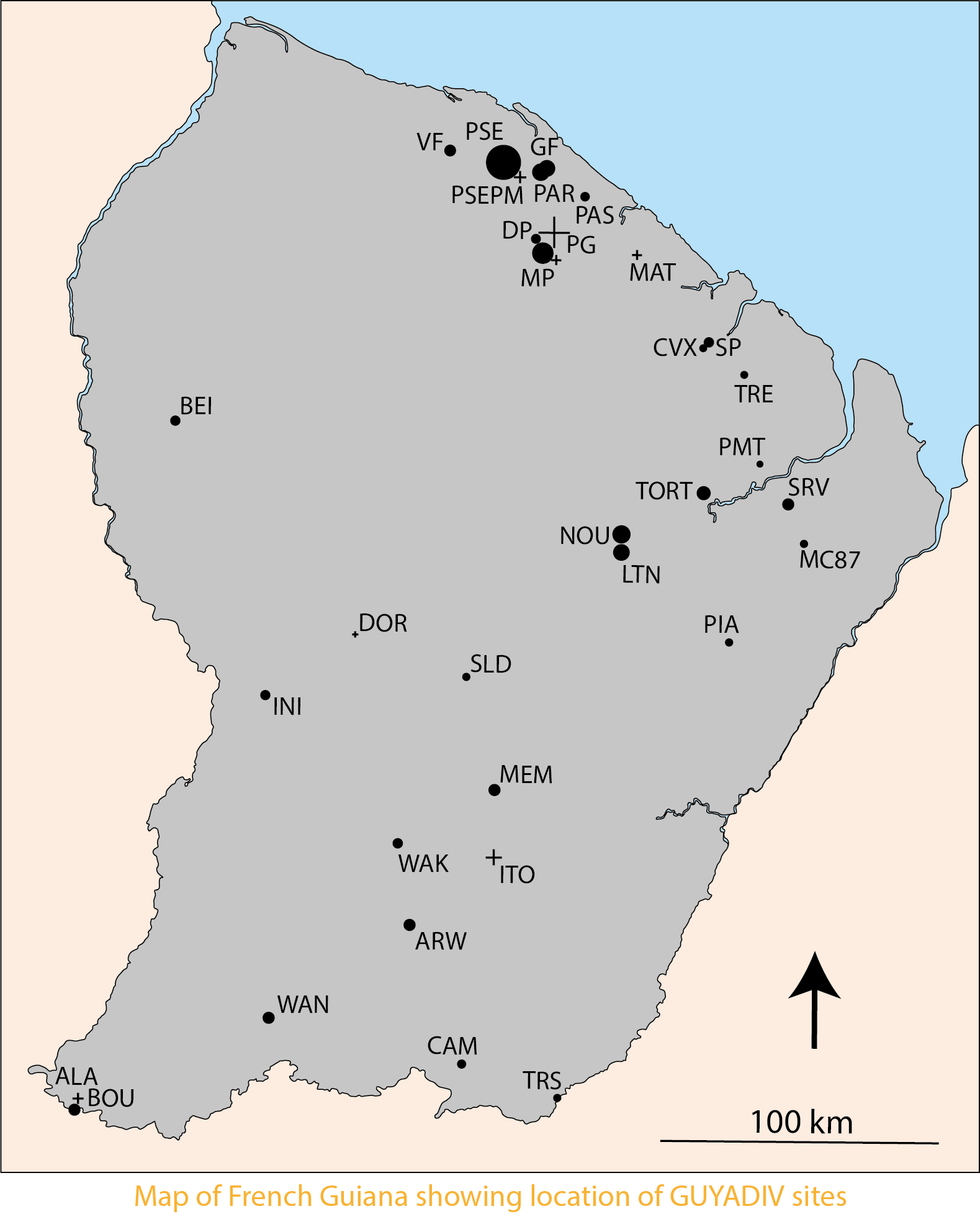
Location of the GUYADIV network plots, covering approximately 100 hectares of forest inventories distributed across French Guiana. Two vector files are provided: - GUYADIV_Plots, in which each plot is represented by its actual geometry. Two types of plots are distinguished: exhaustive ones and inventories conducted using the "Point-Centered Quarter" (PCQ) method. The spatial accuracy of plot locations depends on the geolocation methods used and is documented in the shapefile. Positional uncertainty ranges from about 1 meter for plots surveyed by a professional surveyor, to around 10 meters for GPS-based locations, and up to 100 meters for plots derived from maps. - GUYADIV_Plots_X0Y0, which provides, for most inventories, the geographic coordinates of the PCQ starting point or the plot origin (x0, y0). Further information about the GUYADIV network and the present deposit is available in the following article published in Annals of Forest Science : [URL article]
Overview
Lineage
Links
Downloads
- GUYADIV_Plots Download of vector data " GUYADIV_Plots" in sphapefile format
- GUYADIV_Plots_X0Y0 Download of vector data " GUYADIV_Plots_X0Y0" in shapefile format
- GUYADIV_Plots Download of vector data " GUYADIV_Plots" in Geopackage format
- GUYADIV_Plots_X0Y0 Download of vector data " GUYADIV_Plots_X0Y0 " in Geopackage format
Geolinks
- GUYADIV_Plots_X0Y0 This data is published via the WMS visualization service available at: https://datasuds-geo.ird.fr/geoserver/amap_ws/wms
- GUYADIV_Plots This data is published via the WMS visualization service available at: https://datasuds-geo.ird.fr/geoserver/amap_ws/wms
Others
- Related dataset Molino, Jean-François; Sabatier, Daniel; Engel, Julien, 2024, "The GUYADIV dataset", https://doi.org/10.23708/RLYCVQ, DataSuds
- Link to Original Record [datasuds-geo.ird.fr] This metadata comes from datasuds-geo.ird.fr
- Digital Object Identifier (DOI)
Contacts
DataSuds-geo
UMR AMAP - IRD, UM, CIRAD, CNRS, INRAE - France
UMR AMAP - IRD, UM, CIRAD, CNRS, INRAE - France
UMR AMAP - IRD, UM, CIRAD, CNRS, INRAE - France
UMR AMAP - IRD, UM, CIRAD, CNRS, INRAE - France
Keywords
Constraints
Use limitations
Other restrictions
Good scientific practice requires that the source of these data be cited when used, using the following format:
"SABATIER, D., MOLINO, J.-F. and ENGEL, J. (2026) “GUYADIV forest inventory plots (French Guiana 1986/2018).” DataSuds-geo. doi: 10.23708/8A669C5C-1925-4103-91FB-E4E94776D9D7."