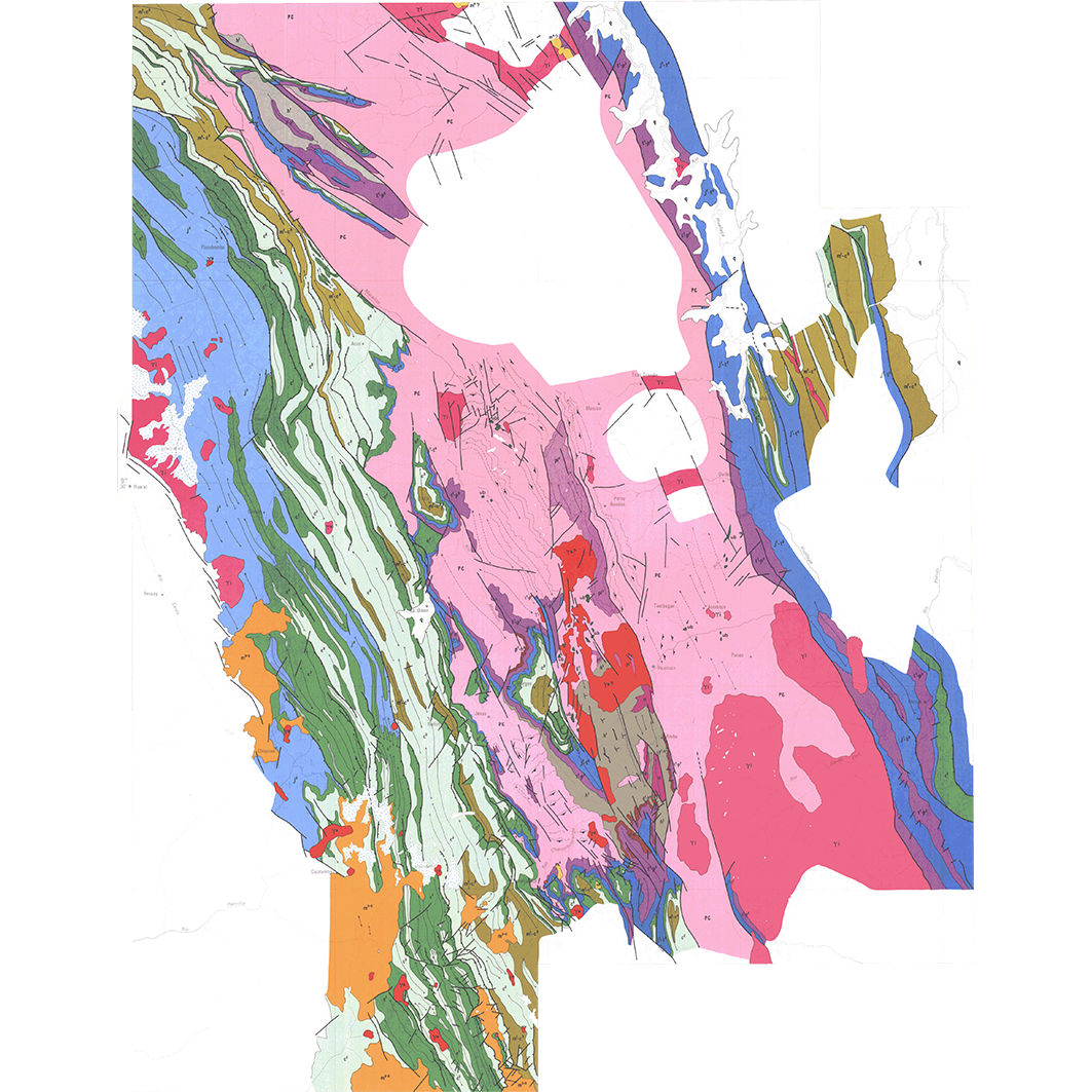
Géologie des Andes péruviennes. Scale of 1:500 000. Date of publication: 1977-1979.
1. Carte géologique de la cordillère orientale du Pérou central : région de Huanuco = Mapa geologico de la cordillera oriental del Peru central : region de Huanuco. / Dalmayrac, B.; Danard, M. (ill.); Scale of 1:500 000. Date of publication: 1979. (file: 01198RC_IRD_PER_GEOL_1979_500000_IRD_PER_GEOL_1977-79_500000.tif) 2. Carte géologique de la cordillière orientale et de l'Altiplano (région nord et nord ouest du Lac Titicaca, Pérou) = Mapa geologico de la cordillera oriental y del Altiplano (region nor y nor oeste del Lago Titicaca, Peru). / Laubacher, G.; Danard, M. (ill.); Scale of 1:500 000. Date of publication: 1977. (file: 01202RC_IRD_PER_GEOL_1977_500000_IRD_PER_GEOL_1977-79_500000.tif) 3. Carte géologique de la déflexion d'Abancay entre San Miguel et Cuzco = Mapa geologico de la deflexion de Abancay entre San Miguel et Cuzco. / Marocco, René; Deruelle, R. (ill.); Scale of 1:500 000. Date of publication: 1977. (file: 01200RC_IRD_PER_GEOL_1977_500000_IRD_PER_GEOL_1977-79_500000.tif)
Overview
Lineage
2. Georeferencing and if possible reprojection to WGS84 (Longitude / Latitude).
3. Clipping and mosaicing of map sheets(s).
4. Export ECW format.
5. ECW to GeoTIFF format conversion.
Links
Downloads
- sphaera_ws:01198RC_IRD_PER_GEOL_1979_500000_IRD_PER_GEOL_1977-79_500000 Carte géologique de la cordillère orientale du Pérou central : région de Huanuco = Mapa geologico de la cordillera oriental del Peru central : region de Huanuco.
- link
- sphaera_ws:01202RC_IRD_PER_GEOL_1977_500000_IRD_PER_GEOL_1977-79_500000 Carte géologique de la cordillière orientale et de l'Altiplano (région nord et nord ouest du Lac Titicaca, Pérou) = Mapa geologico de la cordillera oriental y del Altiplano (region nor y nor oeste del Lago Titicaca, Peru).
- Télécharger au format GeoTIFF Télécharger au format GeoTIFF
- sphaera_ws:01200RC_IRD_PER_GEOL_1977_500000_IRD_PER_GEOL_1977-79_500000 Carte géologique de la déflexion d'Abancay entre San Miguel et Cuzco = Mapa geologico de la deflexion de Abancay entre San Miguel et Cuzco.
- Télécharger au format GeoTIFF Télécharger au format GeoTIFF
Geolinks
- sphaera_ws:01198RC_IRD_PER_GEOL_1979_500000_IRD_PER_GEOL_1977-79_500000 Carte géologique de la cordillère orientale du Pérou central : région de Huanuco = Mapa geologico de la cordillera oriental del Peru central : region de Huanuco.
- sphaera_ws:01202RC_IRD_PER_GEOL_1977_500000_IRD_PER_GEOL_1977-79_500000 Carte géologique de la cordillière orientale et de l'Altiplano (région nord et nord ouest du Lac Titicaca, Pérou) = Mapa geologico de la cordillera oriental y del Altiplano (region nor y nor oeste del Lago Titicaca, Peru).
- sphaera_ws:01200RC_IRD_PER_GEOL_1977_500000_IRD_PER_GEOL_1977-79_500000 Carte géologique de la déflexion d'Abancay entre San Miguel et Cuzco = Mapa geologico de la deflexion de Abancay entre San Miguel et Cuzco.
Others
- Notice explicative ou autre ouvrage Document associé à la carte
- Link to Original Record [datasuds-geo.ird.fr] This metadata comes from datasuds-geo.ird.fr
- Notice explicative ou autre ouvrage Document associé à la carte
- Notice explicative ou autre ouvrage Document associé à la carte
- Digital Object Identifier (DOI)