Le bassin du fleuve Volta. Scale of 1:2 000 000. Date of publication: 1977.
IDS IRD
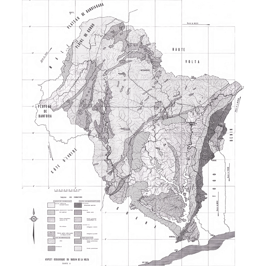
1. Aspect géologique du bassin de la Volta : carte II. / Moniod, F.; Pouyaud, B.; Sechet, P.; Scale of 1:2 000 000. Date of publication: 1977. (file: 13891RC_IRD_GHA_GEOL_1977_2000000_IRD_GHA_CSPA_1977_2000000.tif) 2. Bassin de la Volta : carte des précipitations interannuelles : période d'homogénéisation (1949-1973) 25 ans : carte IV. / Moniod, F.; Pouyaud, B.; Sechet, P.; Scale of 1:2 000 000. Date of publication: 1977. (file: 13892RC_IRD_GHA_CLPR_1977_2000000_IRD_GHA_CSPA_1977_2000000.tif) 3. Bassin de la Volta : relief, réseau hydrographique, équipement hydrométrique : carte I. / Moniod, F.; Pouyaud, B.; Sechet, P.; Scale of 1:2 000 000. Date of publication: 1977. (file: 13890RC_IRD_GHA_HYGR_1977_2000000_IRD_GHA_CSPA_1977_2000000.tif)
publicationDec 31, 1976
Temporal CoverageJan 1, 1977Dec 31, 1977
Overview
1 / 6
Lineage
1. Scanning to tif format, 256 colors, 250dpi.
2. Georeferencing and if possible reprojection to WGS84 (Longitude / Latitude).
3. Clipping and mosaicing of map sheets(s).
4. Export ECW format.
5. ECW to GeoTIFF format conversion.
2. Georeferencing and if possible reprojection to WGS84 (Longitude / Latitude).
3. Clipping and mosaicing of map sheets(s).
4. Export ECW format.
5. ECW to GeoTIFF format conversion.
Links
Downloads
- sphaera_ws:13891RC_IRD_GHA_GEOL_1977_2000000_IRD_GHA_CSPA_1977_2000000 Aspect géologique du bassin de la Volta : carte II.
- link
- sphaera_ws:13892RC_IRD_GHA_CLPR_1977_2000000_IRD_GHA_CSPA_1977_2000000 Bassin de la Volta : carte des précipitations interannuelles : période d'homogénéisation (1949-1973) 25 ans : carte IV.
- Télécharger au format GeoTIFF Télécharger au format GeoTIFF
- sphaera_ws:13890RC_IRD_GHA_HYGR_1977_2000000_IRD_GHA_CSPA_1977_2000000 Bassin de la Volta : relief, réseau hydrographique, équipement hydrométrique : carte I.
- Télécharger au format GeoTIFF Télécharger au format GeoTIFF
Geolinks
- sphaera_ws:13891RC_IRD_GHA_GEOL_1977_2000000_IRD_GHA_CSPA_1977_2000000 Aspect géologique du bassin de la Volta : carte II.
- sphaera_ws:13892RC_IRD_GHA_CLPR_1977_2000000_IRD_GHA_CSPA_1977_2000000 Bassin de la Volta : carte des précipitations interannuelles : période d'homogénéisation (1949-1973) 25 ans : carte IV.
- sphaera_ws:13890RC_IRD_GHA_HYGR_1977_2000000_IRD_GHA_CSPA_1977_2000000 Bassin de la Volta : relief, réseau hydrographique, équipement hydrométrique : carte I.
Others
- Notice explicative ou autre ouvrage Document associé à la carte
- Link to Original Record [datasuds-geo.ird.fr] This metadata comes from datasuds-geo.ird.fr
- Notice explicative ou autre ouvrage Document associé à la carte
- Notice explicative ou autre ouvrage Document associé à la carte
- Digital Object Identifier (DOI)
Keywords
Constraints
licence
Use limitations
Licence : CC-BY-NC-SA