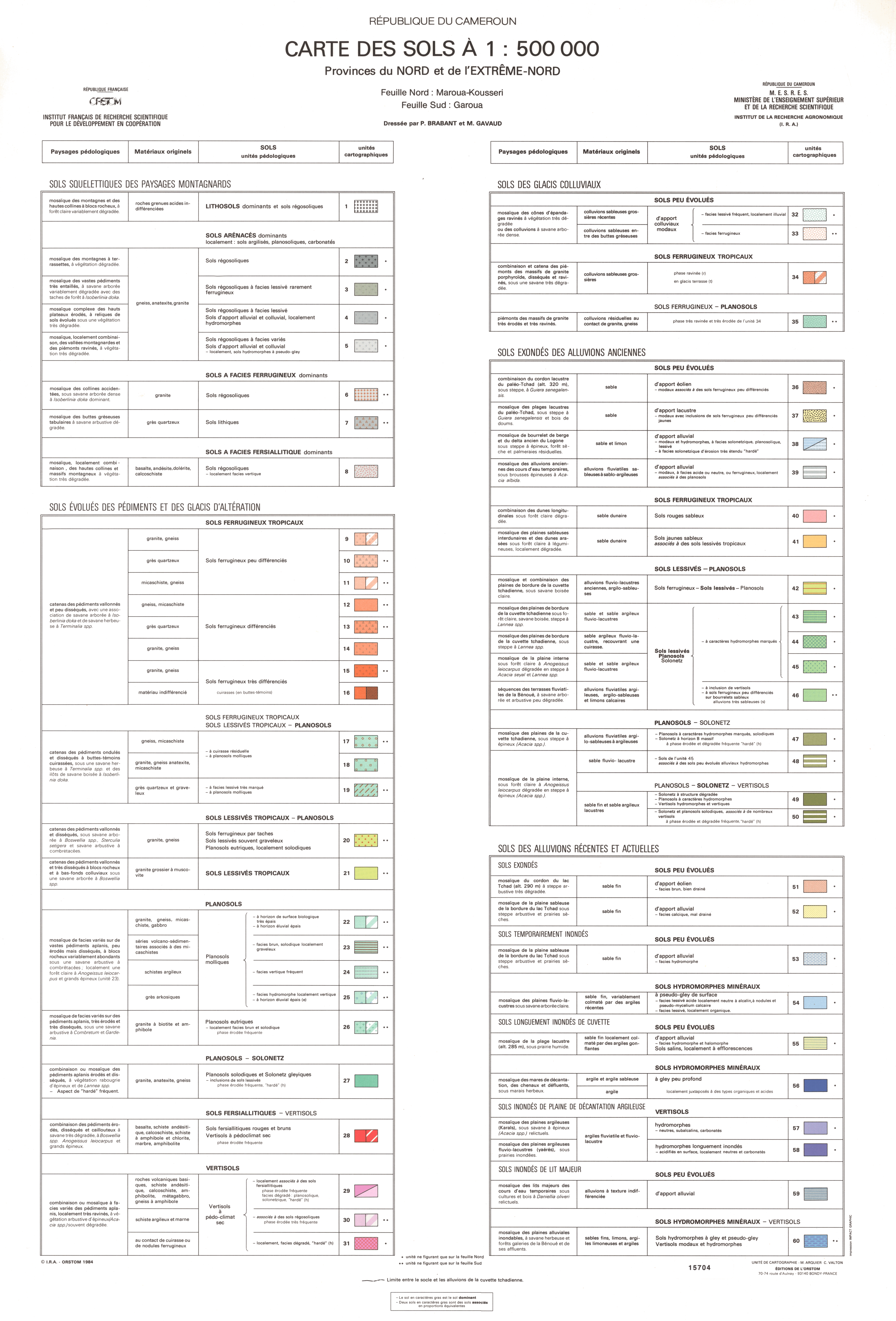
Carte des sols : provinces du Nord et de l'Extrême-Nord. Scale of 1:2 000 000 to 1:500 000. Date of publication: 1984.
1. Carte des sols : provinces du Nord et de l'Extrême-Nord. / Brabant, P.; Arquier, M. (ill.); Gavaud, M.; Valton, C. (ill.); Scale of 1:2 000 000 to 1:500 000. Date of publication: 1984. (files: 00932RC_IRD_CMR_CLPR_1984_2000000_IRD_CMR_PEDO_1984_2000000-500000.tif, 00932RC_IRD_CMR_GEOL_1984_2000000_IRD_CMR_PEDO_1984_2000000-500000.tif, 00932RC_IRD_CMR_GMOR_1984_2000000_IRD_CMR_PEDO_1984_2000000-500000.tif, 00932RC_IRD_CMR_PEDO_1984_2000000_IRD_CMR_PEDO_1984_2000000-500000.tif, 00932RC_IRD_CMR_PEDO_1984_500000_IRD_CMR_PEDO_1984_2000000-500000.tif, 00932RC_IRD_CMR_VEGE_1984_2000000_IRD_CMR_PEDO_1984_2000000-500000.tif) 2. Carte des sols : provinces du Nord et de l'Extrême Nord. / Brabant, P.; Arquier, M. (ill.); Gavaud, M.; Valton, C. (ill.); Scale of 1:500 000. Date of publication: 1984. (file: 00933RC_IRD_CMR_PEDO_1984_500000_IRD_CMR_PEDO_1984_2000000-500000.tif)
Overview
Lineage
2. Georeferencing and if possible reprojection to WGS84 (Longitude / Latitude).
3. Clipping and mosaicing of map sheets(s).
4. Export ECW format.
5. ECW to GeoTIFF format conversion.
Links
Downloads
- sphaera_ws:00932RC_IRD_CMR_CLPR_1984_2000000_IRD_CMR_PEDO_1984_2000000-500000 Carte des sols : provinces du Nord et de l'Extrême-Nord.
- link
- sphaera_ws:00932RC_IRD_CMR_GEOL_1984_2000000_IRD_CMR_PEDO_1984_2000000-500000 Carte des sols : provinces du Nord et de l'Extrême-Nord.
- Télécharger au format GeoTIFF Télécharger au format GeoTIFF
- sphaera_ws:00932RC_IRD_CMR_GMOR_1984_2000000_IRD_CMR_PEDO_1984_2000000-500000 Carte des sols : provinces du Nord et de l'Extrême-Nord.
- Télécharger au format GeoTIFF Télécharger au format GeoTIFF
- sphaera_ws:00932RC_IRD_CMR_PEDO_1984_2000000_IRD_CMR_PEDO_1984_2000000-500000 Carte des sols : provinces du Nord et de l'Extrême-Nord.
- Télécharger au format GeoTIFF Télécharger au format GeoTIFF
- sphaera_ws:00932RC_IRD_CMR_PEDO_1984_500000_IRD_CMR_PEDO_1984_2000000-500000 Carte des sols : provinces du Nord et de l'Extrême-Nord.
- Télécharger au format GeoTIFF Télécharger au format GeoTIFF
- sphaera_ws:00932RC_IRD_CMR_VEGE_1984_2000000_IRD_CMR_PEDO_1984_2000000-500000 Carte des sols : provinces du Nord et de l'Extrême-Nord.
- Télécharger au format GeoTIFF Télécharger au format GeoTIFF
- sphaera_ws:00933RC_IRD_CMR_PEDO_1984_500000_IRD_CMR_PEDO_1984_2000000-500000 Carte des sols : provinces du Nord et de l'Extrême Nord.
- Télécharger au format GeoTIFF Télécharger au format GeoTIFF
Geolinks
- sphaera_ws:00932RC_IRD_CMR_CLPR_1984_2000000_IRD_CMR_PEDO_1984_2000000-500000 Carte des sols : provinces du Nord et de l'Extrême-Nord.
- sphaera_ws:00932RC_IRD_CMR_GEOL_1984_2000000_IRD_CMR_PEDO_1984_2000000-500000 Carte des sols : provinces du Nord et de l'Extrême-Nord.
- sphaera_ws:00932RC_IRD_CMR_GMOR_1984_2000000_IRD_CMR_PEDO_1984_2000000-500000 Carte des sols : provinces du Nord et de l'Extrême-Nord.
- sphaera_ws:00932RC_IRD_CMR_PEDO_1984_2000000_IRD_CMR_PEDO_1984_2000000-500000 Carte des sols : provinces du Nord et de l'Extrême-Nord.
- sphaera_ws:00932RC_IRD_CMR_PEDO_1984_500000_IRD_CMR_PEDO_1984_2000000-500000 Carte des sols : provinces du Nord et de l'Extrême-Nord.
- sphaera_ws:00932RC_IRD_CMR_VEGE_1984_2000000_IRD_CMR_PEDO_1984_2000000-500000 Carte des sols : provinces du Nord et de l'Extrême-Nord.
- sphaera_ws:00933RC_IRD_CMR_PEDO_1984_500000_IRD_CMR_PEDO_1984_2000000-500000 Carte des sols : provinces du Nord et de l'Extrême Nord.
Others
- Notice explicative ou autre ouvrage Document associé à la carte
- Link to Original Record [datasuds-geo.ird.fr] This metadata comes from datasuds-geo.ird.fr
- Notice explicative ou autre ouvrage Document associé à la carte
- Notice explicative ou autre ouvrage Document associé à la carte
- Notice explicative ou autre ouvrage Document associé à la carte
- Notice explicative ou autre ouvrage Document associé à la carte
- Notice explicative ou autre ouvrage Document associé à la carte
- Notice explicative ou autre ouvrage Document associé à la carte
- Digital Object Identifier (DOI)