Cartes de l'élevage pour le Sénégal et la Mauritanie. Scale of 1:2 000 000 to 1:500 000. Date of publication: 1950.
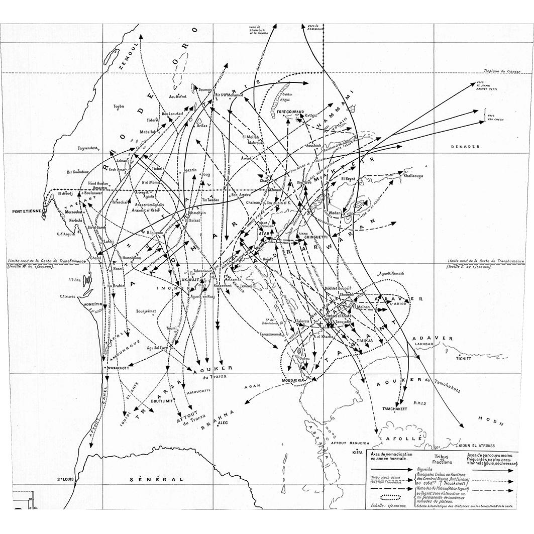
1. Aspect général de la nomadisation en moyenne Mauritanie : cercles de Port-Etienne - Akjoujt - Atar. / Bonnet Dupeyron, F.; Bianconi, G. (ill.); Scale of 1:2 000 000. Date of publication: 1950. (file: 03161RC_IRD_MRT_POEL_1950_2000000_IRD_MRT_POEL_1950_2000000-500000.tif) 2. Déplacements saisonniers des éleveurs en basse et moyenne Mauritanie : (feuille Est). / Bonnet Dupeyron, F.; Bianconi, G. (ill.); Scale of 1:500 000. Date of publication: 1950. (file: 03160RC_IRD_MRT_POEL_1950_500000_IRD_MRT_POEL_1950_2000000-500000.tif) 3. Déplacements saisonniers des éleveurs en basse et moyenne Mauritanie : (feuille Ouest). / Bonnet Dupeyron, F.; Bianconi, G. (ill.); Scale of 1:500 000. Date of publication: 1950. (file: 03159RC_IRD_MRT_POEL_1950_500000_IRD_MRT_POEL_1950_2000000-500000.tif)
Overview
Lineage
2. Georeferencing and if possible reprojection to WGS84 (Longitude / Latitude).
3. Clipping and mosaicing of map sheets(s).
4. Export ECW format.
5. ECW to GeoTIFF format conversion.
Links
Downloads
- sphaera_ws:03161RC_IRD_MRT_POEL_1950_2000000_IRD_MRT_POEL_1950_2000000-500000 Aspect général de la nomadisation en moyenne Mauritanie : cercles de Port-Etienne - Akjoujt - Atar.
- link
- sphaera_ws:03160RC_IRD_MRT_POEL_1950_500000_IRD_MRT_POEL_1950_2000000-500000 Déplacements saisonniers des éleveurs en basse et moyenne Mauritanie : (feuille Est).
- Télécharger au format GeoTIFF Télécharger au format GeoTIFF
- sphaera_ws:03159RC_IRD_MRT_POEL_1950_500000_IRD_MRT_POEL_1950_2000000-500000 Déplacements saisonniers des éleveurs en basse et moyenne Mauritanie : (feuille Ouest).
- Télécharger au format GeoTIFF Télécharger au format GeoTIFF
Geolinks
- sphaera_ws:03161RC_IRD_MRT_POEL_1950_2000000_IRD_MRT_POEL_1950_2000000-500000 Aspect général de la nomadisation en moyenne Mauritanie : cercles de Port-Etienne - Akjoujt - Atar.
- sphaera_ws:03160RC_IRD_MRT_POEL_1950_500000_IRD_MRT_POEL_1950_2000000-500000 Déplacements saisonniers des éleveurs en basse et moyenne Mauritanie : (feuille Est).
- sphaera_ws:03159RC_IRD_MRT_POEL_1950_500000_IRD_MRT_POEL_1950_2000000-500000 Déplacements saisonniers des éleveurs en basse et moyenne Mauritanie : (feuille Ouest).
Others
- Link to Original Record [datasuds-geo.ird.fr] This metadata comes from datasuds-geo.ird.fr
- Digital Object Identifier (DOI)