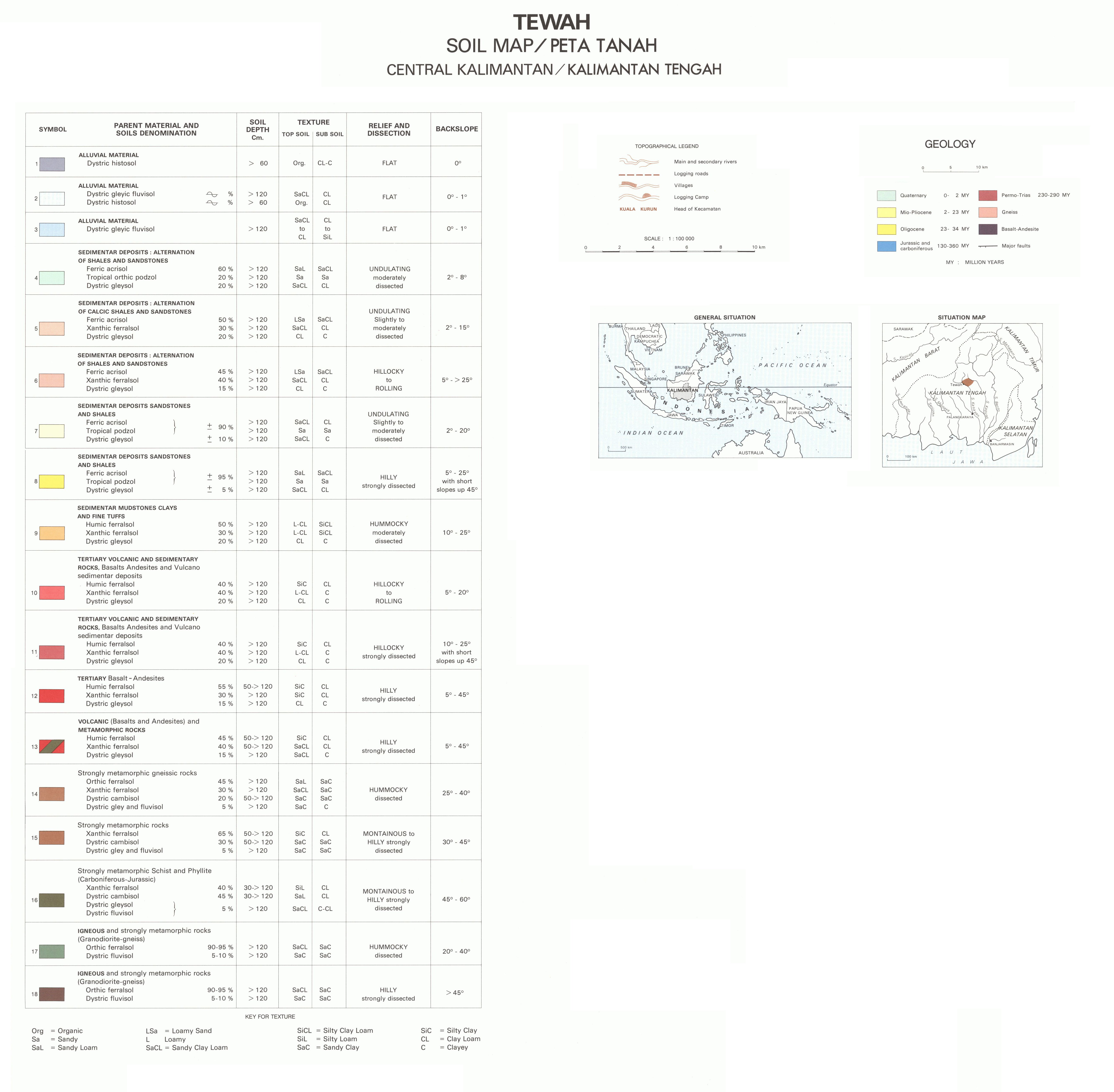
Tewah : soil map : Central Kalimantan : Kalimantan Tengah. Scale of 1:300 000 to 1:100 000. Date of publication: 1986.
IDS IRD
1. Tewah : soil map : Central Kalimantan : Kalimantan Tengah = Tewah : peta tanah : Kalimantan Tengah. / Sieffermann, G.; Bambang, H.; Chauviat, Ch. (ill.); Krisnadjaja; Michonnet, J. L.; Riskan Martens; Sambudhi; Séguin, L. (ill.); Suharto, T.; Bambang, D.S. (collab.) Scale of 1:300 000 to 1:100 000. Date of publication: 1986. (files: 01837RC_IRD_IDN_GEOL_1986_300000_IRD_IDN_PEDO_1986_300000-100000.tif, 01837RC_IRD_IDN_PEDO_1986_100000_IRD_IDN_PEDO_1986_300000-100000.tif)
publicationDec 31, 1985
Temporal CoverageJan 1, 1986Dec 31, 1986
Overview
1 / 3
Lineage
1. Scanning to tif format, 256 colors, 250dpi.
2. Georeferencing and if possible reprojection to WGS84 (Longitude / Latitude).
3. Clipping and mosaicing of map sheets(s).
4. Export ECW format.
5. ECW to GeoTIFF format conversion.
2. Georeferencing and if possible reprojection to WGS84 (Longitude / Latitude).
3. Clipping and mosaicing of map sheets(s).
4. Export ECW format.
5. ECW to GeoTIFF format conversion.
Links
Downloads
- sphaera_ws:01837RC_IRD_IDN_GEOL_1986_300000_IRD_IDN_PEDO_1986_300000-100000 Tewah : soil map : Central Kalimantan : Kalimantan Tengah = Tewah : peta tanah : Kalimantan Tengah.
- link
- sphaera_ws:01837RC_IRD_IDN_PEDO_1986_100000_IRD_IDN_PEDO_1986_300000-100000 Tewah : soil map : Central Kalimantan : Kalimantan Tengah = Tewah : peta tanah : Kalimantan Tengah.
- Télécharger au format GeoTIFF Télécharger au format GeoTIFF
Geolinks
- sphaera_ws:01837RC_IRD_IDN_GEOL_1986_300000_IRD_IDN_PEDO_1986_300000-100000 Tewah : soil map : Central Kalimantan : Kalimantan Tengah = Tewah : peta tanah : Kalimantan Tengah.
- sphaera_ws:01837RC_IRD_IDN_PEDO_1986_100000_IRD_IDN_PEDO_1986_300000-100000 Tewah : soil map : Central Kalimantan : Kalimantan Tengah = Tewah : peta tanah : Kalimantan Tengah.
Others
- Link to Original Record [datasuds-geo.ird.fr] This metadata comes from datasuds-geo.ird.fr
- Digital Object Identifier (DOI)
Keywords
Constraints
licence
Use limitations
Licence : CC-BY-NC-SA