Agbetiko : terroir de la basse vallée du Mono (Sud-Togo). Scale of 1:10 000. Date of publication: 1981.
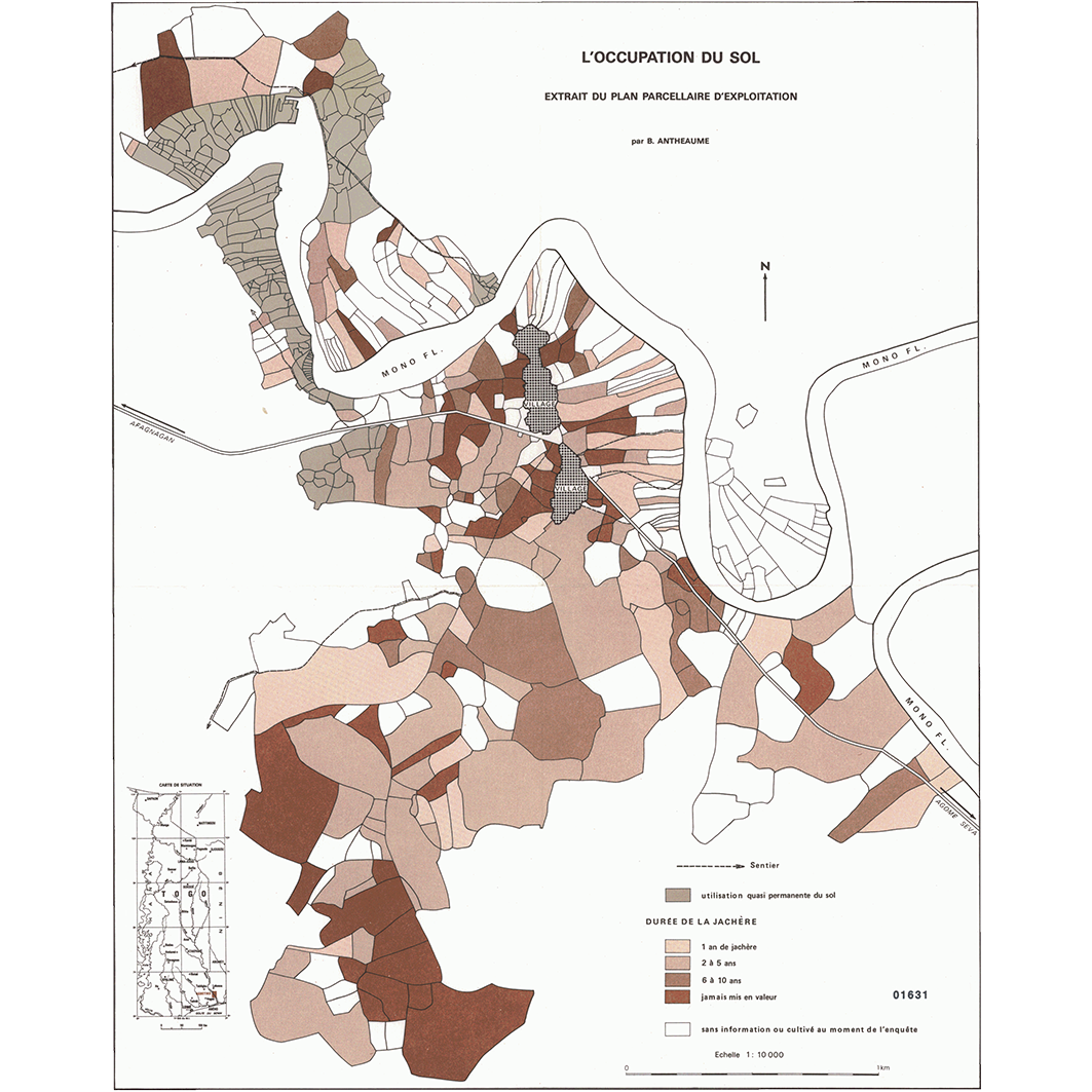
1. Agbetiko : l'occupation du sol : extrait du plan parcellaire d'exploitation. / Antheaume, B.; Douib, A. (ill.); Scale of 1:10 000. Date of publication: 1981. (file: 01631RC_IRD_TGO_USOL_1981_10000_IRD_TGO_CSRE_1981_10000.tif) 2. Agbetiko : la mise en valeur : extrait du plan parcellaire d'exploitation. / Antheaume, B.; Douib, A. (ill.); Scale of 1:10 000. Date of publication: 1981. (file: 01630RC_IRD_TGO_AGEX_1981_10000_IRD_TGO_CSRE_1981_10000.tif) 3. Agbetiko : le kota des propriétaires pour les terres acquises par héritage paternel : extrait du plan parcellaire juridique. / Antheaume, B.; Douib, A. (ill.); Scale of 1:10 000. Date of publication: 1981. (file: 01632RC_IRD_TGO_AGFN_1981_10000_IRD_TGO_CSRE_1981_10000.tif) 4. Agbetiko : les achats de terre : extrait du plan parcellaire juridique. / Antheaume, B.; Douib, A. (ill.); Scale of 1:10 000. Date of publication: 1981. (file: 01633RC_IRD_TGO_AGFN_1981_10000_IRD_TGO_CSRE_1981_10000.tif) 5. Agbetiko : les modes de tenure : extrait du plan parcellaire d'exploitation. / Antheaume, B.; Douib, A. (ill.); Scale of 1:10 000. Date of publication: 1981. (file: 01634RC_IRD_TGO_AGFN_1981_10000_IRD_TGO_CSRE_1981_10000.tif)
Overview
Lineage
2. Georeferencing and if possible reprojection to WGS84 (Longitude / Latitude).
3. Clipping and mosaicing of map sheets(s).
4. Export ECW format.
5. ECW to GeoTIFF format conversion.
Links
Downloads
- sphaera_ws:01631RC_IRD_TGO_USOL_1981_10000_IRD_TGO_CSRE_1981_10000 Agbetiko : l'occupation du sol : extrait du plan parcellaire d'exploitation.
- link
- sphaera_ws:01630RC_IRD_TGO_AGEX_1981_10000_IRD_TGO_CSRE_1981_10000 Agbetiko : la mise en valeur : extrait du plan parcellaire d'exploitation.
- Télécharger au format GeoTIFF Télécharger au format GeoTIFF
- sphaera_ws:01632RC_IRD_TGO_AGFN_1981_10000_IRD_TGO_CSRE_1981_10000 Agbetiko : le kota des propriétaires pour les terres acquises par héritage paternel : extrait du plan parcellaire juridique.
- Télécharger au format GeoTIFF Télécharger au format GeoTIFF
- sphaera_ws:01633RC_IRD_TGO_AGFN_1981_10000_IRD_TGO_CSRE_1981_10000 Agbetiko : les achats de terre : extrait du plan parcellaire juridique.
- Télécharger au format GeoTIFF Télécharger au format GeoTIFF
- sphaera_ws:01634RC_IRD_TGO_AGFN_1981_10000_IRD_TGO_CSRE_1981_10000 Agbetiko : les modes de tenure : extrait du plan parcellaire d'exploitation.
- Télécharger au format GeoTIFF Télécharger au format GeoTIFF
Geolinks
- sphaera_ws:01631RC_IRD_TGO_USOL_1981_10000_IRD_TGO_CSRE_1981_10000 Agbetiko : l'occupation du sol : extrait du plan parcellaire d'exploitation.
- sphaera_ws:01630RC_IRD_TGO_AGEX_1981_10000_IRD_TGO_CSRE_1981_10000 Agbetiko : la mise en valeur : extrait du plan parcellaire d'exploitation.
- sphaera_ws:01632RC_IRD_TGO_AGFN_1981_10000_IRD_TGO_CSRE_1981_10000 Agbetiko : le kota des propriétaires pour les terres acquises par héritage paternel : extrait du plan parcellaire juridique.
- sphaera_ws:01633RC_IRD_TGO_AGFN_1981_10000_IRD_TGO_CSRE_1981_10000 Agbetiko : les achats de terre : extrait du plan parcellaire juridique.
- sphaera_ws:01634RC_IRD_TGO_AGFN_1981_10000_IRD_TGO_CSRE_1981_10000 Agbetiko : les modes de tenure : extrait du plan parcellaire d'exploitation.
Others
- Notice explicative ou autre ouvrage Document associé à la carte
- Link to Original Record [datasuds-geo.ird.fr] This metadata comes from datasuds-geo.ird.fr
- Notice explicative ou autre ouvrage Document associé à la carte
- Notice explicative ou autre ouvrage Document associé à la carte
- Notice explicative ou autre ouvrage Document associé à la carte
- Notice explicative ou autre ouvrage Document associé à la carte
- Digital Object Identifier (DOI)