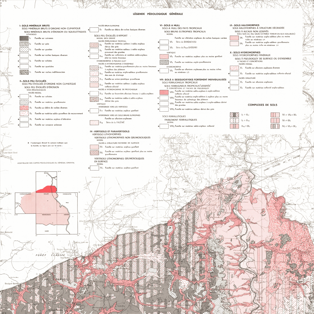
Carte pédologique de reconnaissance du Sénégal. Scale of 1:200 000. Date of publication: 1966-1967.
1. Carte pédologique de reconnaissance au 200 000e : Bakel. / Pereira Barreto, S.; Douib, A. (ill.); Scale of 1:200 000. Date of publication: 1966. (file: 00436RC_IRD_SEN_PEDO_1966_200000_IRD_SEN_PEDO_1966-67_200000.tif) 2. Carte pédologique de reconnaissance au 200 000e : Dalafi. / Kaloga, B.; Scale of 1:200 000. Date of publication: 1966. (file: 00433RC_IRD_SEN_PEDO_1966_200000_IRD_SEN_PEDO_1966-67_200000.tif) 3. Carte pédologique de reconnaissance au 200 000e : Kédougou : République du Sénégal. / Chauvel, A.; Alboucq, G. (ill.); Scale of 1:200 000. Date of publication: 1967. (file: 00435RC_IRD_SEN_PEDO_1967_200000_IRD_SEN_PEDO_1966-67_200000.tif) 4. Carte pédologique de reconnaissance au 200 000e : Kossanto Keniéba. / Chauvel, A.; Alboucq, G. (ill.); Scale of 1:200 000. Date of publication: 1967. (file: 00434RC_IRD_SEN_PEDO_1967_200000_IRD_SEN_PEDO_1966-67_200000.tif) 5. Carte pédologique de reconnaissance au 200 000e : Tambakounda i. / Pereira Barreto, S.; Blic, Philippe de; Douib, A. (ill.);e. Tambacounda. Scale of 1:200 000. Date of publication: 1966. (file: 00437RC_IRD_SEN_PEDO_1966_200000_IRD_SEN_PEDO_1966-67_200000.tif)
Overview
Lineage
2. Georeferencing and if possible reprojection to WGS84 (Longitude / Latitude).
3. Clipping and mosaicing of map sheets(s).
4. Export ECW format.
5. ECW to GeoTIFF format conversion.
Links
Downloads
- sphaera_ws:00436RC_IRD_SEN_PEDO_1966_200000_IRD_SEN_PEDO_1966-67_200000 Carte pédologique de reconnaissance au 200 000e : Bakel.
- link
- sphaera_ws:00433RC_IRD_SEN_PEDO_1966_200000_IRD_SEN_PEDO_1966-67_200000 Carte pédologique de reconnaissance au 200 000e : Dalafi.
- Télécharger au format GeoTIFF Télécharger au format GeoTIFF
- sphaera_ws:00435RC_IRD_SEN_PEDO_1967_200000_IRD_SEN_PEDO_1966-67_200000 Carte pédologique de reconnaissance au 200 000e : Kédougou : République du Sénégal.
- Télécharger au format GeoTIFF Télécharger au format GeoTIFF
- sphaera_ws:00434RC_IRD_SEN_PEDO_1967_200000_IRD_SEN_PEDO_1966-67_200000 Carte pédologique de reconnaissance au 200 000e : Kossanto Keniéba.
- Télécharger au format GeoTIFF Télécharger au format GeoTIFF
- sphaera_ws:00437RC_IRD_SEN_PEDO_1966_200000_IRD_SEN_PEDO_1966-67_200000 Carte pédologique de reconnaissance au 200 000e : Tambakounda i.
- Télécharger au format GeoTIFF Télécharger au format GeoTIFF
Geolinks
- sphaera_ws:00436RC_IRD_SEN_PEDO_1966_200000_IRD_SEN_PEDO_1966-67_200000 Carte pédologique de reconnaissance au 200 000e : Bakel.
- sphaera_ws:00433RC_IRD_SEN_PEDO_1966_200000_IRD_SEN_PEDO_1966-67_200000 Carte pédologique de reconnaissance au 200 000e : Dalafi.
- sphaera_ws:00435RC_IRD_SEN_PEDO_1967_200000_IRD_SEN_PEDO_1966-67_200000 Carte pédologique de reconnaissance au 200 000e : Kédougou : République du Sénégal.
- sphaera_ws:00434RC_IRD_SEN_PEDO_1967_200000_IRD_SEN_PEDO_1966-67_200000 Carte pédologique de reconnaissance au 200 000e : Kossanto Keniéba.
- sphaera_ws:00437RC_IRD_SEN_PEDO_1966_200000_IRD_SEN_PEDO_1966-67_200000 Carte pédologique de reconnaissance au 200 000e : Tambakounda i.
Others
- Notice explicative ou autre ouvrage Document associé à la carte
- Link to Original Record [datasuds-geo.ird.fr] This metadata comes from datasuds-geo.ird.fr
- Notice explicative ou autre ouvrage Document associé à la carte
- Notice explicative ou autre ouvrage Document associé à la carte
- Notice explicative ou autre ouvrage Document associé à la carte
- Notice explicative ou autre ouvrage Document associé à la carte
- Digital Object Identifier (DOI)