Central Kalimantan : Mentaya-East : Tumbang Sepayang : physiographic and hydrographic map. Scale of 1:20 833. Date of publication: 1981-1982.
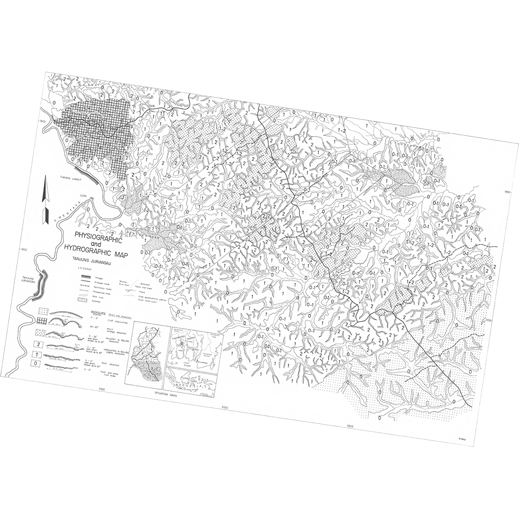
1. Physiographic and hydrographic map : Tanjung Juriangau : Central Kalimantan : Mentaya-East : sheet 3. / Sieffermann, G.; Bambang, D.S. (ill.); Bambang, H.; Budianto, T.; Djoko Pudjiono (ill.); Levang, P.; Marten, R.; Mujidin; Sevin, O.; Sudarmadji; Sudirman; Supoyo, R.; Scale of 1:20 833. Date of publication: 1981. (file: 01842RC_IRD_IDN_EVPH_1981_20833_IRD_IDN_EVPH_1981-82_20833.tif) 2. Physiographic and hydrographic map : Tumbang Sangai : Central Kalimantan : Mentaya-East : sheet 2. / Sieffermann, G.; Bambang, D.S. (ill.); Bambang, H.; Budianto, T.; Levang, P.; Marten, R.; Mujidin; Sevin, O.; Sudarmadji; Sudarno (ill.); Sudirman; Supoyo, R.; Scale of 1:20 833. Date of publication: 1982. (file: 01841RC_IRD_IDN_EVPH_1982_20833_IRD_IDN_EVPH_1981-82_20833.tif) 3. Physiographic and hydrographic map : Tumbang Sepayang : Central Kalimantan : Mentaya-East : sheet 1. / Sieffermann, G.; Bambang, D.S. (ill.); Bambang, H.; Budianto, T.; Djoko Pudjiono (ill.); Levang, P.; Marten, R.; Mujidin; Sevin, O.; Sudarmadji; Sudirman; Supoyo, R.; Scale of 1:20 833. Date of publication: 1981. (file: 01840RC_IRD_IDN_EVPH_1981_20833_IRD_IDN_EVPH_1981-82_20833.tif)
Overview
Lineage
2. Georeferencing and if possible reprojection to WGS84 (Longitude / Latitude).
3. Clipping and mosaicing of map sheets(s).
4. Export ECW format.
5. ECW to GeoTIFF format conversion.
Links
Downloads
- sphaera_ws:01842RC_IRD_IDN_EVPH_1981_20833_IRD_IDN_EVPH_1981-82_20833 Physiographic and hydrographic map : Tanjung Juriangau : Central Kalimantan : Mentaya-East : sheet 3.
- link
- sphaera_ws:01841RC_IRD_IDN_EVPH_1982_20833_IRD_IDN_EVPH_1981-82_20833 Physiographic and hydrographic map : Tumbang Sangai : Central Kalimantan : Mentaya-East : sheet 2.
- Télécharger au format GeoTIFF Télécharger au format GeoTIFF
- sphaera_ws:01840RC_IRD_IDN_EVPH_1981_20833_IRD_IDN_EVPH_1981-82_20833 Physiographic and hydrographic map : Tumbang Sepayang : Central Kalimantan : Mentaya-East : sheet 1.
- Télécharger au format GeoTIFF Télécharger au format GeoTIFF
Geolinks
- sphaera_ws:01842RC_IRD_IDN_EVPH_1981_20833_IRD_IDN_EVPH_1981-82_20833 Physiographic and hydrographic map : Tanjung Juriangau : Central Kalimantan : Mentaya-East : sheet 3.
- sphaera_ws:01841RC_IRD_IDN_EVPH_1982_20833_IRD_IDN_EVPH_1981-82_20833 Physiographic and hydrographic map : Tumbang Sangai : Central Kalimantan : Mentaya-East : sheet 2.
- sphaera_ws:01840RC_IRD_IDN_EVPH_1981_20833_IRD_IDN_EVPH_1981-82_20833 Physiographic and hydrographic map : Tumbang Sepayang : Central Kalimantan : Mentaya-East : sheet 1.
Others
- Notice explicative ou autre ouvrage Document associé à la carte
- Link to Original Record [datasuds-geo.ird.fr] This metadata comes from datasuds-geo.ird.fr
- Notice explicative ou autre ouvrage Document associé à la carte
- Notice explicative ou autre ouvrage Document associé à la carte
- Digital Object Identifier (DOI)