Pina : étude d'un terroir de front pionnier en pays dagari (Haute -Volta). Scale of 1:50 000 to 1:7 500. Date of publication: 1970.
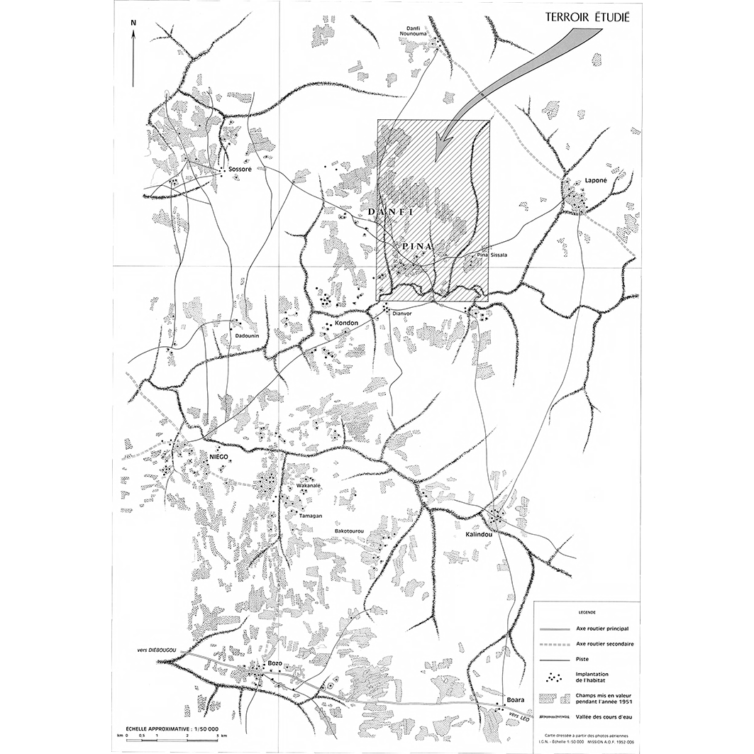
1. Aspect des terroirs de la région de Pina : carte No 1. / Savonnet, Georges; Hardy, B. (ill.); Daumain, M. (collab.); Gautier, Y. (collab.); Le Rouget, G. (collab.) Scale of 1:50 000. Date of publication: 1970. (file: 01414RC_IRD_BFA_AGAS_1970_50000_IRD_BFA_CSRE_1970_50000-7500.tif) 2. Pina : comparaison des terres mises en valeur en 1963 et en 1964 : carte No 7. / Savonnet, Georges; Hardy, B. (ill.); Daumain, M. (collab.); Gautier, Y. (collab.); Le Rouget, G. (collab.) Scale of 1:7 500. Date of publication: 1970. (file: 01420RC_IRD_BFA_USOL_1970_7500_IRD_BFA_CSRE_1970_50000-7500.tif) 3. Pina : Domaines fonciers (année 1964) : carte No 6. / Savonnet, Georges; Hardy, B. (ill.); Daumain, M. (collab.); Gautier, Y. (collab.); Le Rouget, G. (collab.) Scale of 1:7 500. Date of publication: 1970. (file: 01419RC_IRD_BFA_AGFN_1970_7500_IRD_BFA_CSRE_1970_50000-7500.tif) 4. Pina : environnement - déplacement des Yir : carte No 3. / Savonnet, Georges; Hardy, B. (ill.); Daumain, M. (collab.); Gautier, Y. (collab.); Le Rouget, G. (collab.) Scale of 1:7 500. Date of publication: 1970. (file: 01416RC_IRD_BFA_POEL_1970_7500_IRD_BFA_CSRE_1970_50000-7500.tif) 5. Pina : état des cultures en 1963 : carte No 4. / Savonnet, Georges; Hardy, B. (ill.); Daumain, M. (collab.); Gautier, Y. (collab.); Le Rouget, G. (collab.) Scale of 1:7 500. Date of publication: 1970. (file: 01417RC_IRD_BFA_AGCU_1970_7500_IRD_BFA_CSRE_1970_50000-7500.tif) 6. Pina : état des cultures en 1964 : carte No 5. / Savonnet, Georges; Hardy, B. (ill.); Daumain, M. (collab.); Gautier, Y. (collab.); Le Rouget, G. (collab.) Scale of 1:7 500. Date of publication: 1970. (file: 01418RC_IRD_BFA_AGCU_1970_7500_IRD_BFA_CSRE_1970_50000-7500.tif) 7. Pina : végétation, sol et hydrographie : carte No 2. / Savonnet, Georges; Hardy, B. (ill.); Daumain, M. (collab.); Gautier, Y. (collab.); Le Rouget, G. (collab.) Scale of 1:7 500. Date of publication: 1970. (file: 01415RC_IRD_BFA_VEGE_1970_7500_IRD_BFA_CSRE_1970_50000-7500.tif)
Overview
Lineage
2. Georeferencing and if possible reprojection to WGS84 (Longitude / Latitude).
3. Clipping and mosaicing of map sheets(s).
4. Export ECW format.
5. ECW to GeoTIFF format conversion.
Links
Downloads
- sphaera_ws:01414RC_IRD_BFA_AGAS_1970_50000_IRD_BFA_CSRE_1970_50000-7500 Aspect des terroirs de la région de Pina : carte No 1.
- link
- sphaera_ws:01420RC_IRD_BFA_USOL_1970_7500_IRD_BFA_CSRE_1970_50000-7500 Pina : comparaison des terres mises en valeur en 1963 et en 1964 : carte No 7.
- Télécharger au format GeoTIFF Télécharger au format GeoTIFF
- sphaera_ws:01419RC_IRD_BFA_AGFN_1970_7500_IRD_BFA_CSRE_1970_50000-7500 Pina : Domaines fonciers (année 1964) : carte No 6.
- Télécharger au format GeoTIFF Télécharger au format GeoTIFF
- sphaera_ws:01416RC_IRD_BFA_POEL_1970_7500_IRD_BFA_CSRE_1970_50000-7500 Pina : environnement - déplacement des Yir : carte No 3.
- Télécharger au format GeoTIFF Télécharger au format GeoTIFF
- sphaera_ws:01417RC_IRD_BFA_AGCU_1970_7500_IRD_BFA_CSRE_1970_50000-7500 Pina : état des cultures en 1963 : carte No 4.
- Télécharger au format GeoTIFF Télécharger au format GeoTIFF
- sphaera_ws:01418RC_IRD_BFA_AGCU_1970_7500_IRD_BFA_CSRE_1970_50000-7500 Pina : état des cultures en 1964 : carte No 5.
- Télécharger au format GeoTIFF Télécharger au format GeoTIFF
- sphaera_ws:01415RC_IRD_BFA_VEGE_1970_7500_IRD_BFA_CSRE_1970_50000-7500 Pina : végétation, sol et hydrographie : carte No 2.
- Télécharger au format GeoTIFF Télécharger au format GeoTIFF
Geolinks
- sphaera_ws:01414RC_IRD_BFA_AGAS_1970_50000_IRD_BFA_CSRE_1970_50000-7500 Aspect des terroirs de la région de Pina : carte No 1.
- sphaera_ws:01420RC_IRD_BFA_USOL_1970_7500_IRD_BFA_CSRE_1970_50000-7500 Pina : comparaison des terres mises en valeur en 1963 et en 1964 : carte No 7.
- sphaera_ws:01419RC_IRD_BFA_AGFN_1970_7500_IRD_BFA_CSRE_1970_50000-7500 Pina : Domaines fonciers (année 1964) : carte No 6.
- sphaera_ws:01416RC_IRD_BFA_POEL_1970_7500_IRD_BFA_CSRE_1970_50000-7500 Pina : environnement - déplacement des Yir : carte No 3.
- sphaera_ws:01417RC_IRD_BFA_AGCU_1970_7500_IRD_BFA_CSRE_1970_50000-7500 Pina : état des cultures en 1963 : carte No 4.
- sphaera_ws:01418RC_IRD_BFA_AGCU_1970_7500_IRD_BFA_CSRE_1970_50000-7500 Pina : état des cultures en 1964 : carte No 5.
- sphaera_ws:01415RC_IRD_BFA_VEGE_1970_7500_IRD_BFA_CSRE_1970_50000-7500 Pina : végétation, sol et hydrographie : carte No 2.
Others
- Notice explicative ou autre ouvrage Document associé à la carte
- Link to Original Record [datasuds-geo.ird.fr] This metadata comes from datasuds-geo.ird.fr
- Notice explicative ou autre ouvrage Document associé à la carte
- Notice explicative ou autre ouvrage Document associé à la carte
- Notice explicative ou autre ouvrage Document associé à la carte
- Notice explicative ou autre ouvrage Document associé à la carte
- Notice explicative ou autre ouvrage Document associé à la carte
- Notice explicative ou autre ouvrage Document associé à la carte
- Digital Object Identifier (DOI)