Îles Fidji orientales : étude du milieu naturel, de son utilisation et de son évolution sous l'influence humaine, utilisation du milieu. Scale of 1:50 000 to 1:25 000. Date of publication: 1981.
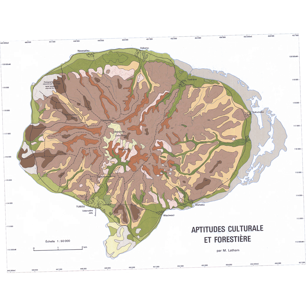
1. Fidji - Fiji : Lakéba : utilisation du milieu : carte d'utilisation des sols = Fidji - Fiji : Lakéba : environment use : land use map. / Brookfield, H. C.; Scale of 1:50 000 to 1:25 000. Date of publication: 1981. (files: 01209RC_IRD_FJI_AGAC_1981_50000_IRD_FJI_USOL_1981_50000-25000.tif, 01209RC_IRD_FJI_USOL_1981_25000_IRD_FJI_USOL_1981_50000-25000.tif, 01209RC_IRD_FJI_VEGE_1981_50000_IRD_FJI_USOL_1981_50000-25000.tif) 2. Fidji - Fiji : Taveuni : utilisation du milieu : carte d'aptitudes culturale et forestière - carte d'utilisation des sols = Fidji - Fiji : Taveuni : environment use : map of land suitability for agriculuture and forestry - land use map. / Denis, B.; Brookfiled, H. C.; Scale of 1:50 000. Date of publication: 1981. (files: 01211RC_IRD_FJI_AGAC_1981_50000-01_IRD_FJI_USOL_1981_50000-25000.tif, 01211RC_IRD_FJI_AGAC_1981_50000-02_IRD_FJI_USOL_1981_50000-25000.tif, 01211RC_IRD_FJI_USOL_1981_50000-01_IRD_FJI_USOL_1981_50000-25000.tif, 01211RC_IRD_FJI_USOL_1981_50000-02_IRD_FJI_USOL_1981_50000-25000.tif)
Overview
Lineage
2. Georeferencing and if possible reprojection to WGS84 (Longitude / Latitude).
3. Clipping and mosaicing of map sheets(s).
4. Export ECW format.
5. ECW to GeoTIFF format conversion.
Links
Downloads
- sphaera_ws:01209RC_IRD_FJI_AGAC_1981_50000_IRD_FJI_USOL_1981_50000-25000 Fidji - Fiji : Lakéba : utilisation du milieu : carte d'utilisation des sols = Fidji - Fiji : Lakéba : environment use : land use map.
- link
- sphaera_ws:01209RC_IRD_FJI_USOL_1981_25000_IRD_FJI_USOL_1981_50000-25000 Fidji - Fiji : Lakéba : utilisation du milieu : carte d'utilisation des sols = Fidji - Fiji : Lakéba : environment use : land use map.
- Télécharger au format GeoTIFF Télécharger au format GeoTIFF
- sphaera_ws:01209RC_IRD_FJI_VEGE_1981_50000_IRD_FJI_USOL_1981_50000-25000 Fidji - Fiji : Lakéba : utilisation du milieu : carte d'utilisation des sols = Fidji - Fiji : Lakéba : environment use : land use map.
- Télécharger au format GeoTIFF Télécharger au format GeoTIFF
- sphaera_ws:01211RC_IRD_FJI_AGAC_1981_50000-01_IRD_FJI_USOL_1981_50000-25000 Fidji - Fiji : Taveuni : utilisation du milieu : carte d'aptitudes culturale et forestière - carte d'utilisation des sols = Fidji - Fiji : Taveuni : environment use : map of land suitability for agriculuture and forestry - land use map.
- Télécharger au format GeoTIFF Télécharger au format GeoTIFF
- sphaera_ws:01211RC_IRD_FJI_AGAC_1981_50000-02_IRD_FJI_USOL_1981_50000-25000 Fidji - Fiji : Taveuni : utilisation du milieu : carte d'aptitudes culturale et forestière - carte d'utilisation des sols = Fidji - Fiji : Taveuni : environment use : map of land suitability for agriculuture and forestry - land use map.
- Télécharger au format GeoTIFF Télécharger au format GeoTIFF
- sphaera_ws:01211RC_IRD_FJI_USOL_1981_50000-01_IRD_FJI_USOL_1981_50000-25000 Fidji - Fiji : Taveuni : utilisation du milieu : carte d'aptitudes culturale et forestière - carte d'utilisation des sols = Fidji - Fiji : Taveuni : environment use : map of land suitability for agriculuture and forestry - land use map.
- Télécharger au format GeoTIFF Télécharger au format GeoTIFF
- sphaera_ws:01211RC_IRD_FJI_USOL_1981_50000-02_IRD_FJI_USOL_1981_50000-25000 Fidji - Fiji : Taveuni : utilisation du milieu : carte d'aptitudes culturale et forestière - carte d'utilisation des sols = Fidji - Fiji : Taveuni : environment use : map of land suitability for agriculuture and forestry - land use map.
- Télécharger au format GeoTIFF Télécharger au format GeoTIFF
Geolinks
- sphaera_ws:01209RC_IRD_FJI_AGAC_1981_50000_IRD_FJI_USOL_1981_50000-25000 Fidji - Fiji : Lakéba : utilisation du milieu : carte d'utilisation des sols = Fidji - Fiji : Lakéba : environment use : land use map.
- sphaera_ws:01209RC_IRD_FJI_USOL_1981_25000_IRD_FJI_USOL_1981_50000-25000 Fidji - Fiji : Lakéba : utilisation du milieu : carte d'utilisation des sols = Fidji - Fiji : Lakéba : environment use : land use map.
- sphaera_ws:01209RC_IRD_FJI_VEGE_1981_50000_IRD_FJI_USOL_1981_50000-25000 Fidji - Fiji : Lakéba : utilisation du milieu : carte d'utilisation des sols = Fidji - Fiji : Lakéba : environment use : land use map.
- sphaera_ws:01211RC_IRD_FJI_AGAC_1981_50000-01_IRD_FJI_USOL_1981_50000-25000 Fidji - Fiji : Taveuni : utilisation du milieu : carte d'aptitudes culturale et forestière - carte d'utilisation des sols = Fidji - Fiji : Taveuni : environment use : map of land suitability for agriculuture and forestry - land use map.
- sphaera_ws:01211RC_IRD_FJI_AGAC_1981_50000-02_IRD_FJI_USOL_1981_50000-25000 Fidji - Fiji : Taveuni : utilisation du milieu : carte d'aptitudes culturale et forestière - carte d'utilisation des sols = Fidji - Fiji : Taveuni : environment use : map of land suitability for agriculuture and forestry - land use map.
- sphaera_ws:01211RC_IRD_FJI_USOL_1981_50000-01_IRD_FJI_USOL_1981_50000-25000 Fidji - Fiji : Taveuni : utilisation du milieu : carte d'aptitudes culturale et forestière - carte d'utilisation des sols = Fidji - Fiji : Taveuni : environment use : map of land suitability for agriculuture and forestry - land use map.
- sphaera_ws:01211RC_IRD_FJI_USOL_1981_50000-02_IRD_FJI_USOL_1981_50000-25000 Fidji - Fiji : Taveuni : utilisation du milieu : carte d'aptitudes culturale et forestière - carte d'utilisation des sols = Fidji - Fiji : Taveuni : environment use : map of land suitability for agriculuture and forestry - land use map.
Others
- Notice explicative ou autre ouvrage Document associé à la carte
- Link to Original Record [datasuds-geo.ird.fr] This metadata comes from datasuds-geo.ird.fr
- Notice explicative ou autre ouvrage Document associé à la carte
- Notice explicative ou autre ouvrage Document associé à la carte
- Notice explicative ou autre ouvrage Document associé à la carte
- Notice explicative ou autre ouvrage Document associé à la carte
- Notice explicative ou autre ouvrage Document associé à la carte
- Notice explicative ou autre ouvrage Document associé à la carte
- Digital Object Identifier (DOI)