Tiogo : étude géographique d'un terroir léla (Haute-Volta). Scale of 1:2 000 000 to 1:2 000. Date of publication: 1968.
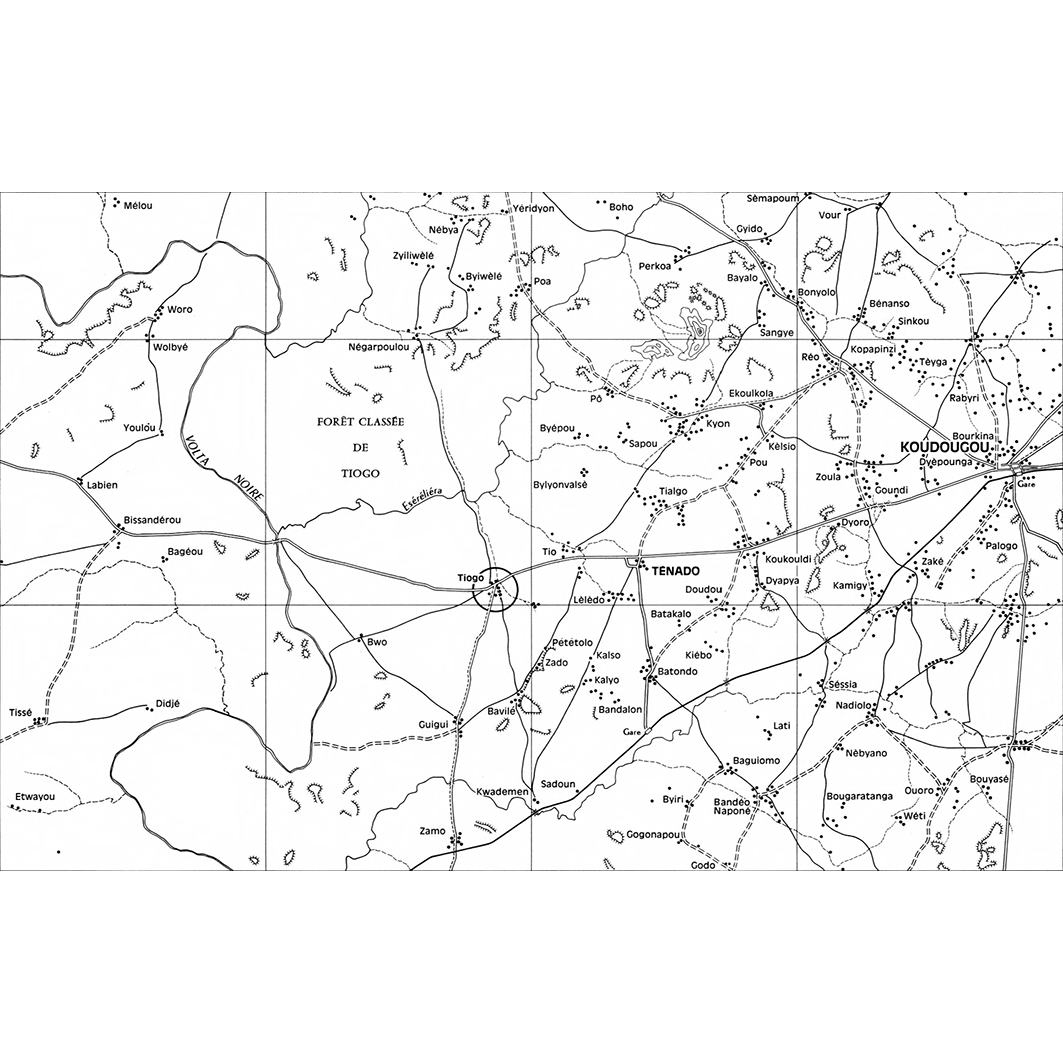
1. Cartes de situation : planche I - situation géographique du pays Léla et planche II - situation de Tiogo. / Barral, Henri; Hardy, B. (ill.); Scale of 1:2 000 000 to 1:300 000. Date of publication: 1968. (files: 01385RC_IRD_BFA_ILSI_1968_2000000_IRD_BFA_CSRE_1968_2000000-2000.tif, 01385RC_IRD_BFA_ILSI_1968_300000_IRD_BFA_CSRE_1968_2000000-2000.tif) 2. Tiogo : détail du centre du village : planche V. / Barral, Henri; Hardy, B. (ill.); Scale of 1:2 000. Date of publication: 1968. (file: 01388RC_IRD_BFA_ESGM_1968_2000_IRD_BFA_CSRE_1968_2000000-2000.tif) 3. Tiogo : partages et limites du terroir : planche VIII. / Barral, Henri; Hardy, B. (ill.); Scale of 1:20 000. Date of publication: 1968. (file: 01391RC_IRD_BFA_AGFN_1968_20000_IRD_BFA_CSRE_1968_2000000-2000.tif) 4. Tiogo : plan d'implantation de l'habitat : planche III. / Barral, Henri; Hardy, B. (ill.); Scale of 1:5 000. Date of publication: 1968. (file: 01386RC_IRD_BFA_INHA_1968_5000_IRD_BFA_CSRE_1968_2000000-2000.tif) 5. Tiogo : relevé des cultures de Gwara en 1962 : planche IV. / Barral, Henri; Hardy, B. (ill.); Scale of 1:5 000. Date of publication: 1968. (file: 01387RC_IRD_BFA_AGCU_1968_5000_IRD_BFA_CSRE_1968_2000000-2000.tif) 6. Tiogo : structures foncières : planche VI. / Barral, Henri; Hardy, B. (ill.); Scale of 1:5 000. Date of publication: 1968. (file: 01389RC_IRD_BFA_AGFN_1968_5000_IRD_BFA_CSRE_1968_2000000-2000.tif) 7. Tiogo : zone des champs de brousse : planche VII. / Barral, Henri; Hardy, B. (ill.); Scale of 1:20 000. Date of publication: 1968. (file: 01390RC_IRD_BFA_USOL_1968_20000_IRD_BFA_CSRE_1968_2000000-2000.tif)
Overview
Lineage
2. Georeferencing and if possible reprojection to WGS84 (Longitude / Latitude).
3. Clipping and mosaicing of map sheets(s).
4. Export ECW format.
5. ECW to GeoTIFF format conversion.
Links
Downloads
- sphaera_ws:01385RC_IRD_BFA_ILSI_1968_2000000_IRD_BFA_CSRE_1968_2000000-2000 Cartes de situation : planche I - situation géographique du pays Léla et planche II - situation de Tiogo.
- link
- sphaera_ws:01385RC_IRD_BFA_ILSI_1968_300000_IRD_BFA_CSRE_1968_2000000-2000 Cartes de situation : planche I - situation géographique du pays Léla et planche II - situation de Tiogo.
- Télécharger au format GeoTIFF Télécharger au format GeoTIFF
- sphaera_ws:01388RC_IRD_BFA_ESGM_1968_2000_IRD_BFA_CSRE_1968_2000000-2000 Tiogo : détail du centre du village : planche V.
- Télécharger au format GeoTIFF Télécharger au format GeoTIFF
- sphaera_ws:01391RC_IRD_BFA_AGFN_1968_20000_IRD_BFA_CSRE_1968_2000000-2000 Tiogo : partages et limites du terroir : planche VIII.
- Télécharger au format GeoTIFF Télécharger au format GeoTIFF
- sphaera_ws:01386RC_IRD_BFA_INHA_1968_5000_IRD_BFA_CSRE_1968_2000000-2000 Tiogo : plan d'implantation de l'habitat : planche III.
- Télécharger au format GeoTIFF Télécharger au format GeoTIFF
- sphaera_ws:01387RC_IRD_BFA_AGCU_1968_5000_IRD_BFA_CSRE_1968_2000000-2000 Tiogo : relevé des cultures de Gwara en 1962 : planche IV.
- Télécharger au format GeoTIFF Télécharger au format GeoTIFF
- sphaera_ws:01389RC_IRD_BFA_AGFN_1968_5000_IRD_BFA_CSRE_1968_2000000-2000 Tiogo : structures foncières : planche VI.
- Télécharger au format GeoTIFF Télécharger au format GeoTIFF
- sphaera_ws:01390RC_IRD_BFA_USOL_1968_20000_IRD_BFA_CSRE_1968_2000000-2000 Tiogo : zone des champs de brousse : planche VII.
- Télécharger au format GeoTIFF Télécharger au format GeoTIFF
Geolinks
- sphaera_ws:01385RC_IRD_BFA_ILSI_1968_2000000_IRD_BFA_CSRE_1968_2000000-2000 Cartes de situation : planche I - situation géographique du pays Léla et planche II - situation de Tiogo.
- sphaera_ws:01385RC_IRD_BFA_ILSI_1968_300000_IRD_BFA_CSRE_1968_2000000-2000 Cartes de situation : planche I - situation géographique du pays Léla et planche II - situation de Tiogo.
- sphaera_ws:01388RC_IRD_BFA_ESGM_1968_2000_IRD_BFA_CSRE_1968_2000000-2000 Tiogo : détail du centre du village : planche V.
- sphaera_ws:01391RC_IRD_BFA_AGFN_1968_20000_IRD_BFA_CSRE_1968_2000000-2000 Tiogo : partages et limites du terroir : planche VIII.
- sphaera_ws:01386RC_IRD_BFA_INHA_1968_5000_IRD_BFA_CSRE_1968_2000000-2000 Tiogo : plan d'implantation de l'habitat : planche III.
- sphaera_ws:01387RC_IRD_BFA_AGCU_1968_5000_IRD_BFA_CSRE_1968_2000000-2000 Tiogo : relevé des cultures de Gwara en 1962 : planche IV.
- sphaera_ws:01389RC_IRD_BFA_AGFN_1968_5000_IRD_BFA_CSRE_1968_2000000-2000 Tiogo : structures foncières : planche VI.
- sphaera_ws:01390RC_IRD_BFA_USOL_1968_20000_IRD_BFA_CSRE_1968_2000000-2000 Tiogo : zone des champs de brousse : planche VII.
Others
- Notice explicative ou autre ouvrage Document associé à la carte
- Link to Original Record [datasuds-geo.ird.fr] This metadata comes from datasuds-geo.ird.fr
- Notice explicative ou autre ouvrage Document associé à la carte
- Notice explicative ou autre ouvrage Document associé à la carte
- Notice explicative ou autre ouvrage Document associé à la carte
- Notice explicative ou autre ouvrage Document associé à la carte
- Notice explicative ou autre ouvrage Document associé à la carte
- Notice explicative ou autre ouvrage Document associé à la carte
- Notice explicative ou autre ouvrage Document associé à la carte
- Digital Object Identifier (DOI)